
Anyone know how far they have gotten on plowing highway 150 (mirror lake loop road) coming from Kamas? I see someone posted that they have opened the gate on the Bear River side and you can trailer a ways up the road. Can you do that on the west side? Looking to go ride someplace high on Sunday, weather gurus are saying the snow level is going to creep up to 11,000+ FT Sunday afternoon before the cold front comes through. Might be a rainy ride.
Install the app
How to install the app on iOS
Follow along with the video below to see how to install our site as a web app on your home screen.
Note: This feature may not be available in some browsers.
You are using an out of date browser. It may not display this or other websites correctly.
You should upgrade or use an alternative browser.
You should upgrade or use an alternative browser.
HWY 150 Plowing Status??
- Thread starter CSUpowder
- Start date
S
sled addiction
Well-known member
its only plowed to the ranger station,
not much room to turn around if there is more than 4 or 5 trucks and trailer there.
they need to plow out some more room for us die hard sleders!
not much room to turn around if there is more than 4 or 5 trucks and trailer there.
they need to plow out some more room for us die hard sleders!
its only plowed to the ranger station,
not much room to turn around if there is more than 4 or 5 trucks and trailer there.
they need to plow out some more room for us die hard sleders!
I believe the OP was asking about the Kamas side of the hwy.
I believe the OP was asking about the Kamas side of the hwy.
Who cares about the Kamas side. LOL
Road out of the kamas side today... Plowed about 2-3 miles past the gate with a decent turnaround ( big truck + 18 foot trailer was tight)
Make sure when you park you don't block the turnaround, had to yell at a few idoiots today.
Road is ok for first couple of miles, but many spots are down to pavement. Murdock basin turnoff has plenty of snow. Anything above murdock has a lot. No chance they can plow above that. Prepair for whoop, there's about a million of them!
S
snengineer
Well-known member
I just got this off UDOT's website. Looks like the 4th of July will be a sled trip for sure!
UTAH DEPARTMENT OF TRANSPORTATION
TRAFFIC OPERATIONS CENTER
SEASONAL
STATE ROUTE CLOSURE LIST
Updated Tuesday, May 24, 2011
This list is limited to UDOT’s numbered State Routes, and does not include local county or forest
roads.
Note: This report does not include temporary incident road closures.
Check the “Emergency Alerts” and “Road Conditions Alerts” links on the CommuterLink home page for active
temporary road closures.
SR 35 Wolf Creek Pass Anticipated Opening Mid-June CLOSED
Francis to Hanna – Milepost 12 to 37
SR 39 Monte Cristo Anticipated Opening Mid June CLOSED
East of Ogden – Milepost 37 to 55.5
SR 65 East Canyon Anticipated Opening Mid June CLOSED
Northeast of Salt Lake City – Milepost 3 to 13.2
SR 92 American Fork Canyon / Alpine Loop Anticipated Opening mid-June CLOSED
Milepost 14 to 22.5
Snow-rated tires are required from November through March from US-189 at Milepost 27 to Aspen Grove at Milepost 22.
SR 148 Cedar Breaks
East of Cedar City – Milepost 0.2 to 19 CLOSED
SR 150 Mirror Lake Highway Anticipated Opening Late-June CLOSED
Kamas to Wyoming Border – Milepost 14.6 to 48
SR 153 Mount Holly Junction Anticipated Opening mid-June
East of Beaver – Milepost 23 to 35 CLOSED
SR 190 Guardsman Pass Anticipated Opening Late June
Big Cottonwood Canyon (SR-190/Brighton) to Park City (Junction with SR 224) CLOSED
SR 224 Guardsman Pass Anticipated Opening Late June
Park City to Midway CLOSED
Lake Powell Ferry OPEN
Use SR 95 as an alternate.

As of 06-02-2011 the Kamas side is plowed to about a half mile or so below murdock basin turn-off. The road is a bit whooped out but no more bare spot's. Riding is still great especially for June.
R
Rock Star
Well-known member
i drive up there daily to run the dog on snow. Currently cut to 20.6 miles up. so, as stated just below Murdock Basin turn off. Trial Lake turn is at 26 and Bald summit is at 30 I think. so 5.5 miles of admission fee (whopps) before endless riding. amazing. It's 2 feet deep on the road at 20.6, 4' deep at Provo falls and 6 to 8' deep at Trial lake. June 1 is usually about a mile in most directions from the Bald Summit. this year there is no less than 500 Sq Miles of snow to ride here. EPIC! and yes.. some dumb asses keep parking in the turn around. WTF? so I leave them kind notes. haa
S
snengineer
Well-known member
Any updates this week? Are we still parking a mile below Murdock Basin Turnoff?
so 5.5 miles of admission fee (whopps) before endless riding.
What is this admission fee for? How much?
What is this admission fee for? How much?
LMAO!!
LMAO!!
It always make me happy when I can entertain.
S
snengineer
Well-known member
Any updates this week? Are we still parking a mile below Murdock Basin Turnoff?
We parked at the same location Friday, 1 mile below Murdock Basin turnoff. It wasn't till 1 mile (1.5 on the way out) down the road that the snow was continuously covering the road, mostly spotty but a couple good several hundred yard stretches of bare asphalt. I imagine that by today they will have it pushed to the gorge area. Riding conditions were very good, First of May type snow, lake's below 10k are starting to get damp on the edges. Still a ton of snow up there as you can see below!


Making progress I see...
Anyone been up 35? is that opened up yet?
Anyone been up 35? is that opened up yet?
We parked at the same location Friday, 1 mile below Murdock Basin turnoff. It wasn't till 1 mile (1.5 on the way out) down the road that the snow was continuously covering the road, mostly spotty but a couple good several hundred yard stretches of bare asphalt. I imagine that by today they will have it pushed to the gorge area. Riding conditions were very good, First of May type snow, lake's below 10k are starting to get damp on the edges. Still a ton of snow up there as you can see below!
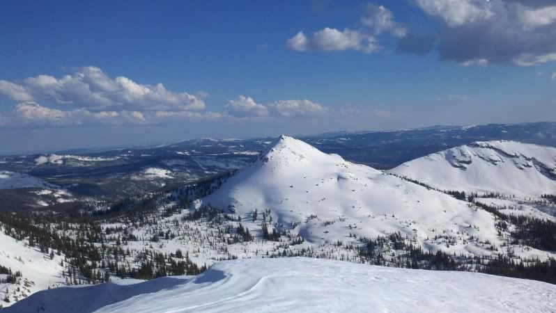
Island Peak or Cone Peak as its referred to Has the most snow i have ever seen on it. Usually you can climb it by picking your way through large rocks. Its a wild ride, but i put my route to the top on there. So nice to still have alot of snow!!!

J
JohnnyQuestUtah
Well-known member

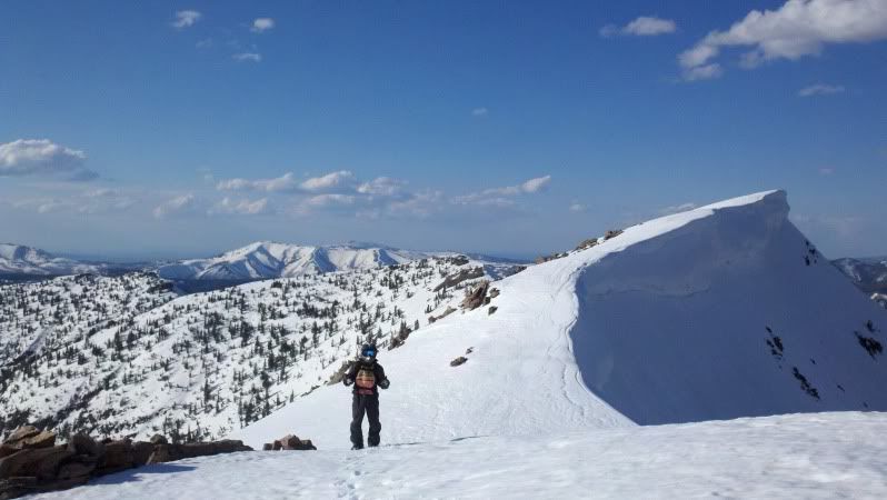
Just a bit above Lilly Lake, 6-22-2011
Peace-
Just a bit above Lilly Lake, 6-22-2011
Peace-
Yo, thats the road gap jump! our kicker is still on top of the rocks in the picture... should make for some good shots on saturday! thanks for posting! They are getting close to the top with plowing!
Similar threads
J
- Replies
- 0
- Views
- 2K
J
L
- Replies
- 216
- Views
- 26K