Install the app
How to install the app on iOS

Follow along with the video below to see how to install our site as a web app on your home screen.

Note: This feature may not be available in some browsers.

  • Don't miss out on all the fun! Register on our forums to post and have added features! Membership levels include a FREE membership tier.

Irwin report

Thread Rating
5.00 star(s)
12/16/08

CB Avalanche Forecast: The danger is HIGH today. Travel in the backcountry is not recomended.

It warmed up considerably last night - snowed pretty good. We got 10" of now snow down in town, and I'm expecting to see 1-2 feet up at Irwin today. There has been lots of high winds with this storm, so expect lots of snow loading. Expect up to another foot at most throughout the day today.

We'll be grooming this evening and trying to get Splain's Gulch trail open.
If the snow is stable we'll cut it open all the way back to Kebler Pass from Ohio Pass - a few shovel shear tests will determine whether we can cut open the sidehill w /the cat.

MtnDoo

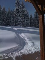
Here's a picture from the Irwin Townsite yesterday *before* the storm!
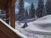
front_yard_sm.jpg front_yard_sm2.jpg
 
Last edited:
Just got back to town - no pics today.
It's officially winter!

Average of an honest 3 feet past the Y, at the rolling hills, townsite and above - and snowed all day.

Turbo groomed the main roads this afternoon - Kebler, Campground Access road, and rolling hills up to the base of Ruby.
Said he had snow over the tracks of the cat!

Only about 5 or so other sleds out there today - pure powder perfection.
Light, dry, deep.

Can't wait to cut open Splains Gulch open tonight.

MtnDoo
 
8/17/08

So, yesterday Turbo (our main groomer feller) spent 12 hrs in the cat.

Newly groomed trails are:

- Kebler Pass Road to summit
- 2mi portion of Ohio Pass Rd.
- Kebler Pass down to Horse Thief Park
- Y to Rolling Hills/Ruby
- Townsite Road
- Old Kebler Pass Road
- Floresta Access Road (private, stay out! ;-)

- Splains Gulch from Kebler to Ohio Pass


Busting out Splain's Gulch road with the snowcat was amazing - and scary!
I'll attach a few pics. Snow was 4-6' deep, over the cat's tracks and often over the cat's blade. The meadows were deep, but the Trees were unbelievable.

The Kebler pass entrance to Splain's is sketchy at best. We set off a large avalanche below the cat at the first large meadow - 3' deep slab side, and you could see fractures all around above us. Be careful if you're traveling through that area. Best to enter Splain's from the Ohio Pass side.

Anyways - it's all groomed, great access and bottomless powder stashes galore! Have fun and be safe this weekend!

If you see Turbo (Rick) out there in the cat this weekend - be sure to thank him for all of the extra work!

MtnDoo

snow_over_splains.jpg floresta_snowcat_barn.jpg floresta_lodge.jpg
 
Last edited:
Gunnison/Crested Butte is the trailhead for this area. It is actually a lot better drive than anywhere near the I-70 corridor. It may be further in distance but drive time is almost always shorter!


Lots of hotels and other lodging in both areas. I think most stay in Gunnsion though.


It is big coutry out at Iriwin, huge bowls with major avy danger...be prepared
 
How far is it to this area from Castle Rock? What roads do you take? Places to stay?

Several ways to go from Castle Rock but I would recommend going south on 25 to Colorado Springs then take 24 up through Woodland Park out through Hartsell on over to Poncha Springs. Get on 50 there and turn right, go over Monarch Pass and West on 50 to Gunnison. You can find it from there no doubt. Lots of motels in Gunnison. It is about 200 miles from Castle Rock and takes about 4.5 hours. I used to do it all the time.
 
For all of you Western Slope'ers - Turbo is grooming accross to Erriccsson Springs today. Phil just took him up extra fuel.

Should be a fun weekend!

MD.
 
Great to hear, may try to ride up from Ericson Springs this weekend if I get lucky. Thanks a ton for the consistant quality reports! Much appreciated!
 
You're all welcome!
I'm glad folks are checking/reading this thread.
I'll try to keep it up throughout the season.
If you need any planning your visit, or help while you're in the area, feel free to PM me.

We got about another 3-4" last night till this afternoon.
Enough to fill in a bit of the cat's path in Splain's Gulch.

MD.

**********************************************************************

Here's the forecast from CB Avalanche Center:

Crested Butte Avalanche Report
Reported Wednesday, December 17, 2008 at 6:40 AM

Weather Forecast

Tonight:
Snow, 2-4" additional. Winds moving to the South 5-15 mph and lows in the teens.

Tomorrow:
Snow, 3-6" expected. Southwest winds 10-20 mph and highs in the upper 20's.


Weather Synopsis

Low pressure off of the coast of California is dropping further South, tapping into warmer air and drawing in more Pacific moisture. We should see the effects of this tonight and tomorrow as the low begins to move inland. A brief break in heavy snowfall today, with things picking up again tonight and tomorrow. A cold front is programmed to reach the area tomorrow afternoon, increasing snowfall again and dropping temperatures. Look for snow to continue through Saturday, with some clearing on Sunday.
In the Backcountry

Another 8" of new snow in the past 24 hours here in town will equate to a lot more in the mountains. We have seen strong winds in the past day, especially near and above treeline. This will be continuing to build wind slabs on Easterly slopes. With little snow overnight, and only light snow today, the snowpack will get a chance to adjust to this new load today. I would expect natural activity to slow down today, but as this next round of snow arrives tomorrow, accompanied by strong winds, expect the avalanche danger to rise again.
 
Last edited:
12/19 Update, Fatality

SW'ers,

Well we had lots of snow, and tons of wind over the last week.
Today the sun came out in the afternoon and probably added some weight to the snowpack, but it was very cold in the PM.

On a serious note, we had our first fatality of the season here in Crested Butte. A fellow was skiing the Climax Chutes on the north side of Mt.Emmons and went down - solo, no ave gear, terrain trap - but a very accomplished skier, local employee and brother of an Irwin resident. Body is still on the mountain, recovery efforts are on-going. Sad deal all around.

After loosing a ski patroller in Aspen last week, and now this one - it's clear that we should stay clear of climbing big walls, or anything over 30 degree slope for now.

SO...BE CAREFUL OUT THERE! There are several distinct layers in the snowpack, and about two to three good weak/releasable layers are evident if you do a shovel shear test.

Lots of pow to play on, lots of sun.
Be smart - stay alive!

MtnDoo


**********************CB Avalanche Center Snip********************************************

Crested Butte Avalanche Report

Reported Friday, December 19, 2008 at 6:25 AM


Weather Forecast

Today:
Becoming cloudy with light snow developing in the afternoon. T-2" possible, with little acumulation in Gunnison. Winds from the Southwest 10-20 mph gusting to 35 mph and highs will be near 20.

Tonight:
Light snowfall over the mountains 1-3" possible. Southwest winds 10-20 mph and lows below zero.

Tomorrow:
Cloudy with light snowfall. West winds 10-20 mph and highs only in the teens.


Weather Synopsis

A dry slot has opened up, giving us a break in snowfall this morning. The next shortwave of moisture looks to arrive this afternoon and this evening, giving us some more modest snowfall. A more Northwesterly jetstream this weekend will keep snowfall lighter than we have seen, with colder temperatures and very cold windchill values. Another big hit looks to arrive Monday night, with snow continuing for much of next week.
In the Backcountry

Recent heavy snowfall and strong winds have deposited yet another large load onto our tender snowpack. We are seeing the midpack stiffen up and become more supportive. This will allow for greater propagation of any failure in the snowpack, allowing avalanches to be triggered from a distance and creating larger slides.


We also have seen several slides triggered on a buried surface hoar layer, as well as failures on differing storm layers from the past week. While these instabilities will get better over time, only in depth snow pit analisys will show where these weaknesses are a problem.

Reports indicate that there may have been an avalanche accident in the Climax Chutes area of Mt. Emmons. No details are available at this time, but this is a reminder that we are in the midst of a big storm and avalanche cycle. Now is not the time for powder fever and to be pushing it in the backcountry. Any slope steeper than 30 degrees should be treated as unstable right now, and avoided. Be also aware of the potential for natural avalanches to releaser on slopes near you.
 
Last edited:
12/21

Snowed a bit yesterday, a few inches of accumulation, very cold all day - LOTS of strong, gusting winds and snow movement. All of the steep walls are failing now - Pittsburgh(Slate River Valley-Daisy Pass area) had a 2000' natural slide - Best to hone those meadow carving skills right now and avoid anything over 30 degrees of pitch.

MtnDoo

******************************************************


More conditions at cbavalanchecenter.org

From CB Ave Center:

In the Backcountry

The body of Mike Bowen was found yesterday at the bottom of the Happy Chutes in a large pile of debris just up from the valley floor. After finding a hat and pole above his exact location was pinpointed by a dog. He was found 4 feet under the debris without his snowboard or backpack. We will post a more detailed accident investigation soon. Lots of variability in our snowpack currently coming out of a major avalanche cycle. Reports of a large natural avalanche, probably yesterday, running 2,000' in the Pittsburg area prove the avalanche danger is still high in places. Many steep paths have slid to the ground or near the ground. Yesterdays wind were strong and transported a lot of snow and stripped some areas. Steep slopes that have not slid yet remain the most suspect at this time. Areas with their complete snowpack have a large load sitting on top of a weak base. These slopes are still very unstable and will release naturally or with the smallest of triggers. Winds have created new wind slabs that could have filled in old crowns and bed surfaces where slides already occured. These wind slabs could be quite far down the slopes today, as well some gullies can be loaded from the side due to significant crossloading. Watch out for the possibility of old slide paths filling back in and becoming again unstable.
 
yikes! 4 guys and my self are heading out on the 25th from wisconsin. I hope the snow comes around. Im sure we will still have a great time. Thanks for all the info! We will stay in the deep and off the steep for now.
 
Hi All,

Thanks for the PM's - I'm glad folks are reading this.

The clouds came in last night, dropped 2-3" in town, more above.
Yesterday's brief viewing of Colorado's blue skies and sun is quickly gone.

Lots of solid, low-lying fog, so be sure you have your bearings as visibility is likely a challenge above. Snow is getting deeeep! Turbo(Rick) went out and groomed last night - most of the main routes. Our grooming schedule has changed for now, and will be as follows:

Wednesday: Kebler - Crested Butte to Erriccson Springs*
Friday: Kebler - Main Trails
Sunday: Kebler - Splains, Rolling hills, clean up from weekend riders

* this will begin again once we can get the new auxiliary tank plumed on the snowcat. (required for the additional range)

Deep and sub-surface instabilities persist - stay off steep slopes until our base and sub-surface layers bond better. Avoid terrain traps. It's sugar city out there right now. Lots of skier/snowmobiler triggered and natural slides persist; many going right down to the dirt with the weak layers from early storms. Another suspect layer exists about a foot to two feet below surface. Two fatalities have occurred in our mountain ranges recently; that warning speaks loudly enough.

I'm heading up this morning, and will report on actuals later in the day.

Enjoy!

MtnDoo


************CB Avalanche Center Snip*********************************


Reported Monday, December 22, 2008 at 6:25 AM

Weather Forecast (again, just multiply by 2x or 3x in back country, and add wind)

Today:
Cloudy, 4-6" possible, Winds southwest at 15-25 mph and highs in the 20's.

Tonight:
Cloudy, 3-5" possible, winds southwest 10-20 mph, Lows in the teens.

Tomorrow:
Cloudy, 1-3" possible, west winds 10-20 mph, Highs in the 20's.


Weather Synopsis

Expect the snow to continue and increase with the winds throughout the day as the flow swings to the southwest. A wave of moisture should leave us with a pleasantly significant amount of new snow by Tuesday morning. There may be a possible short break Tuesday night before another block of moisture moves in to our area on Wednesday. The end of the week is a long ways away but it too is looking like it is going to continue to add to our overall snow depths.


In the Backcountry

In the Elks we have an overall snowpack that is weak and variable. Multiple layers of weak unstable snow can be found throughout the entire pack. Although there is not a lot of energy in the snowpack, previous winds and new snow today could be enough to puch us into another avalnche cycle. Field observations are showing east shears both near the surface and at the bottom of the snowpack. Skier triggered avalanches will remain probable today. Watch for the danger to rise today if we get significant amounts of new snow and the wind increases.
 
12/22/08 4:30pm

Just got down to town.
It seems that yesterday's afternoon sun created another hard layer about 6" below the current surface. (6" has fallen since). It was snowing at a rate of about 2" per hour this afternoon give or take a bit.

Still dumping.

MD.
 
Premium Features


Back
Top