Install the app
How to install the app on iOS

Follow along with the video below to see how to install our site as a web app on your home screen.

Note: This feature may not be available in some browsers.

  • Don't miss out on all the fun! Register on our forums to post and have added features! Membership levels include a FREE membership tier.

Bearclaw Bob's 2

Thread Rating
5.00 star(s)
Sunny to Cloudy

Good afternoon from Cooke city. The snowman is calling for a 20% chance of snow for the next 2 days. Then it raises to 30% on Sunday and 40 % on Monday. The temps are going to be in the mid 20's.

AVALANCHE CONDITONS: The odds of triggering an avalanche have dropped since just two days ago when heavy snowfall spiked the avalanche danger. The snowpack was not producing many avalanches prior to this storm and did not produce as many avalanches as we expected following the storm.
What does all this mean? The snowpack overall appears to have supported this recent load of snow fairly well. Weak layers in the snowpack either do not exist or have been mostly unreactive. To be sure, dig a snowpit and perform at least one stability test. Look for a weak layer just under the new snow 1-3 feet deep. If the snowpack is relatively thin (less than 3 feet deep) assess facets in the bottom foot. Many stable slopes exist especially in the Bridger Range and near Cooke City.

It’s tricky today because pockets of instability exist where triggering an avalanche will be easy to do. Unfortunately there’s no clear pattern where these pockets exist. With heightened avalanche conditions in these specific places, the avalanche danger is rated MODERATE
 
BRRRRRRRRRRRRRR

Woke up to 5 below with clear skies. The snowman is telling me that we will see warmer temp's at night and mid 20's during the day. The out look for snow will be starting Monday with a 40% chance. While today through Sunday will be a 20% chance.

AVALANCHE CONDITONS:

Triggering an avalanche remains definitely possible. Avalanches should be confined to smaller pockets breaking 1-3 feet deep. A group riding near Cooke City on steep, treed slopes triggered a slide on Wednesday near Lulu Pass. They also triggered one yesterday near Daisy Pass about 100 feet wide, 150 feet long, and several feet deep. Two were caught but not buried yesterday. These slides are good reminders to expose one person at a time and to make sure to keep eyes on our partners even when crossing small slopes. Simple tasks but hard to do when riding in thick trees.
With pockets of instability lurking on isolated slopes, heightened avalanche conditions exist in specific places but these slopes are hard to identify without putting your shovel in the snow and testing buried weak layers. Today the avalanche danger is rated MODERATE.

The number one seller at the bakery was the Breakfast Burger. mmmmmmm

I've put HMK boots on sale, come by and check them out. I've got several Snowpulse Avy packs left, if your still looking for a good deal.
 
Cloudy

Good morning from the town of Cooke city. The snowman changed his mind this morning to Cloudy. He is saying the chance of snow also has went down to 50%. We might see 2 inches Sunday and a slight chance Sunday night and Monday. Lows will be in the teens.

AVALANCHE CONDITONS: Lionhead area near West Yellowstone Cooke City

Heavy snowfall Sunday and Monday spiked the avalanche danger, but things have mellowed out a lot since then. Why? The snowpack has persistent weak layers but they are not widespread. It’s a tricky situation because many slopes may be stable while a few may not be.

Small avalanches were triggered by riders on Wednesday and Thursday near Cooke City. A larger one also occurred near Cooke City several days ago.

Even though many have been safely skiing and riding in avalanche terrain, these recent slides remind us to be prepared. Expose one person at a time and watch your partners from safe zones. Also, consider the consequences of a slide. Terrain traps make small avalanches deadly.

Heightened avalanche conditions exist in specific places but these slopes are hard to identify without putting your shovel in the snow and testing buried weak layers. Because avalanches remain possible today, the avalanche danger is rated MODERATE.

The Breakfast Burrito won Number 1 at the bakery today.

I had several guys come in this morning and bring me a enlarged photo of them jumping and one of the sleds was my rental. The photo was used in Snow goer magazine and it was called "TRIPLE THREAT". I would like to thank them again for the gift.

I would like to thank everyone that reads my posts or comes in and says HI.
:welcome:
 
Snowing

Woke up to a Good morning with about an inch of snow and snowing lightly. The snowman is saying now that we could see 4 inches by tomorrow morning. The temp's will be in the mid 20's and double digits at night. Lets wait and see what he brings us.

AVALANCHE CONDITIONS: There’s just something not right about driving in January with your windshield wipers on. But that’s exactly what happened at 4 a.m. this morning when I drove into town. Another round of wet snow and freezing rain is gracing the valley while dense snow accumulates in the mountains.

For better or for worse, this latest round of snow isn’t enough to steadily increase the avalanche danger. However, if snow continues to accumulate throughout the day, it could become enough weight/stress to put the snowpack on edge. Fortunately this weak storm system has arrived with very little wind which will keep the formation of fresh wind slabs to a minimum.


A layer of small grained facets or surface hoar can be found 1-2 feet below the surface. This layer produced a few small human triggered avalanches last week around Cooke City. Two separate groups of skiers also got this layer to propagate in stability tests in the northern Gallatin Range yesterday.

Today - Heightened avalanche conditions exist and the avalanche danger is rated MODERATE.

If your looking for parts, check me out and see if I have what you need.
The garage is heated to store or work on your sleds.
 
Sunny

--------------------------------------------------------------------------------

Good morning from Bearclaw and Super 8. Here is a recap from the last two days. It was cloudy Monday with the high in the lower 20's ( no snow). Tuesday, had several wrecker calls and it was sunny and upper 20's. The snowman today is calling for temps to reach 30. We are in a high pressure front that will last till Friday, when we might see snow for the weekend. At this time its 4 below.

AVALANCHE CONDITONS: Yesterday I rode around Cooke City looking a layer of surface hoar buried two feet under the surface. My partners and I dug six snowpits on different aspects and found this layer in four of them and breaking in only two (photo). An extended column test on Mt. Abundance took 32 whacks to fully break across and another on Henderson Bench took 21 hits, a trend toward strengthening and stability. We rode by two small avalanches in Miller Creek that were triggered on very steep slopes by sledders and snowbikers on Wednesday and Thursday. Dig two feet down and test the snow before committing to a steep line. For today, the avalanche danger is rated MODERATE on all slopes steeper than 35 degrees and LOW on less steep terrain.

IMG_0632.jpg
 
COLD

I hate to say, I thought I saw a penquin this morning walking down the road. It was another cold morning, 10 below. :face-icon-small-con The snowman is calling for a slight chance of snow for the next 5 days. The temp's are going to be in the mid 20's and teens at night.

AVALANCHE CONDITIONGS: Near Cooke City the only weak layer in the snowpack is surface hoar buried 1.5 feet deep. A few small avalanches were triggered on this weak layer a week ago. This weak layer has a sporadic distribution and should be less sensitive than it was last week. For today the avalanche danger is rated MODERATE on all slopes steeper than 35 degrees and LOW on less steep terrain.

I've had a lot of calls if I fill Avy tanks. YES I do. I also rent out the garage to let store or work on your sleds. I do carry parts for sleds. Stop in and see if I have what your looking for. I will work on your sled. I've got 28 years of experience.
 
Warmer

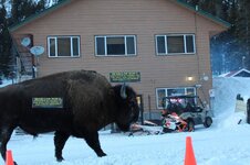
Heres what I found out later in the day. It wasn't a penquin, it was our pet Buffalo walking up the street. So I roped him and put a banner on him for advertising.
The snowman is still calling for 2 inches by tonight and an inches over night. Winds came up, with gusts to 30 mph. The temp was 26 this morning. By Monday we should see temps in the mid 30's.

AVALANCHE CONDITONS: Today the avalanche danger is rated MODERATE on slopes steeper than 35 degrees and LOW on less steep terrain. Heads up: The surface snow has another layer of surface hoar on it (photo). This layer has been seen near Cooke City and West Yellowstone. Strong winds today will hopefully knock down these crystals before they are capped and preserved by the new snow tonight.

IMG_0633.jpg buff advertizing.jpg
 
Last edited:
MORE SNOW

--------------------------------------------------------------------------------

Good morning from Cooke City. Woke up at 3 am and 22 degrees, to find 2 inches of snow. At this time we have 3-4 inches and still snowing. The snowman is calling for another 4 inches today, with temps in the mid 30's. Tonight maybe another inch will fall. For Monday, temps will be in the mid 20's and a 50 % chance of snow.

AVALANCHE CONDITIONS: The southern half of the advisory area has been favored by a moist westerly flow. Over the past 48 hours Fisher Creek Snotel site near Cooke City has picked up over eight inches of snow totaling .8 inches of SWE. Carrot Basin in the southern Madison Range has received 6 inches of snow totaling .6 inches of SWE and Madison Plateau near West Yellowstone is up to 5 inches of snow totaling .5 inches of SWE.

The snowpack in these areas is strong and should have little trouble supporting this recent load. Yesterday, Mark and his partner skied in the southern Madison Range near Lightning Creek and found a stable snowpack. He found no discernable weak layers near the ground or mid-pack. Similar snowpack conditions exist around West Yellowstone and Cooke City.

This makes today’s primary avalanche concern new snow instabilities - mainly fresh wind slabs. The new snow will be pushed around by moderate to strong west-southwest winds which will create dense slabs in upper elevation, leeward terrain. With more snow and wind in the forecast, winds slabs will grow in size and distribution throughout the day. These slabs may be a bit stubborn due to the warmer temperatures, but I still wouldn’t trust any steep, wind loaded slope today.

For this reason human triggered avalanches are likely on steep, wind loaded slopes which have a CONSIDERABLE avalanche danger. Steep, non-wind loaded slopes have a MODERATE avalanche danger and generally safe conditions exist in less steep terrain which has a LOW avalanche danger.
 
Taking Over Town....29 Deep

We are back in Cooke City this week with enough flatlanders to track up all of the easy stuff, lol.We arrived on Sunday with 29 Flatlanders ready to rip.

The snowman has comith with more unforecasted snow. Like a magic eraser, the hills are all new again. It is going to be another great week at Bearclaw Bob's, Super 8, and the Bearclaw Bakery. Fresh pastries and fluffy new snow, a great start to your mountain morning.

10606156_671674529609434_8391325019658126912_n.jpg


10896889_671674646276089_7843070919896128661_n.jpg


11593_671674546276099_6666582914322540708_n.jpg


10906006_671674856276068_6104955633250775999_n.jpg


10940620_671674786276075_757090123166634927_n.jpg


The avalanche forecast from Avalanche.Org
Cooke City is a snow magnet. Over the past three days Fisher Creek Snotel site has recorded over a foot of snow totaling 1.7 inches of SWE (snow water equivalent). This new snow has provided plenty of ammunition for transport and wind slab development.

Upper elevation slopes leeward to west-southwest winds will be likely locations to encounter wind-drifted snow. With temperatures on the warm side, newly created wind-slabs will be stiff and stubborn. Although not hair trigger, recently formed wind slabs will likely fail under the weight of a skier or rider.

A secondary avalanche concern is a layer of buried surface hoar. The distribution of this layer is questionable, but it likely survived in isolated areas. With over a foot of new snow now capping it, this layer has the ability to catch you by surprise. I would be especially wary of buried surface hoar if skiing or riding on steep, sheltered slopes below treeline.

Today for the mountains around Cooke City, Human triggered avalanches are likely on wind loaded slopes which have a CONSIDERABLE avalanche danger. Non-wind loaded slopes have a MODERATE avalanche danger.
 
became sunny

Good evening from Cooke City. A recap from Monday. The snowman brought us a inch Monday, while we woke up to about 12 inches in town this morning. The next couple of days we are going to see sunny skies with a temp in the mid 20's and 2 below for the night. Should be a great week of riding with over 2 feet of fresh snow on the mountain.

AVALANCHE CONDITIONS:

The mountains around Cooke City are greedy and not sharing their bounty with the rest of us. Since Friday close to two feet of snow has fallen (2 inches of SWE). Winds were strong out of the west over the weekend, but lessened yesterday. We have not received reports of avalanche activity because for the most part, this snow fell onto a strong snowpack. The interface between the old snow surface and the new snow is where avalanches may break. Clear weather before the storm may have created weak facets at the surface, but these instabilities are not widespread. Wind-loading at the upper elevations along with two feet of new snow is creating a MODERATE avalanche danger on all slopes since natural avalanches are unlikely yet triggering them is possible.
 
Thank you Bob for keeping Cooke City such a great place to visit. Your hard work, constant dedication and first hand knowledge are irreplaceable.

Yesterday was a great day to be on the mountain. As Bob mentioned and you will see from the photos below, we had some fresh in town and on the mountain.
The weather and wind has been a bit brisk.

10923304_672231122887108_5010888407269518321_n.jpg


10931470_672231159553771_4304482755694352267_n.jpg


10801829_672231226220431_7048714160413659418_n.jpg


10891885_672231269553760_8295215189847340095_n.jpg


1461579_672231329553754_7495454615161765088_n.jpg


10942311_672231382887082_3639761137387040907_n.jpg


10933767_672231436220410_2259008173216240834_n.jpg


10403372_672231819553705_1717820665056389498_n.jpg


10414880_672232619553625_935170574580927336_n.jpg


The mountains around Cooke City are greedy and not sharing their bounty with the rest of us. Since Friday close to two feet of snow has fallen (2 inches of SWE). Winds were strong out of the west over the weekend, but lessened yesterday. We have not received reports of avalanche activity because for the most part, this snow fell onto a strong snowpack. The interface between the old snow surface and the new snow is where avalanches may break. Clear weather before the storm may have created weak facets at the surface, but these instabilities are not widespread. Wind-loading at the upper elevations along with two feet of new snow is creating a MODERATE avalanche danger on all slopes since natural avalanches are unlikely yet triggering them is possible.
 
Nice pics Jacob. Keep them coming. I miss the breakfast burritos so much! Be safe!

Bill


Sent from my iPhone using Tapatalk
 
Nice pics Jacob. Keep them coming. I miss the breakfast burritos so much! Be safe!

Bill


Sent from my iPhone using Tapatalk

I wake up drooling in the spring thinking of the big green burritos.

We had some bitter cold weather overnight again. No more fresh but the sun was out for a great day of ripping the fresh that is setting up. Climbing and boondocking through the trees is a blast with the snow pack now. The forecast is calling for some fresh this weekend.

1509690_672791366164417_4455853358309041242_n.jpg


994466_672791042831116_1173732293249061175_n.jpg


10930517_672791112831109_1168455483030326001_n.jpg


10931476_672791226164431_9093128731370727980_n.jpg


10924756_672791306164423_4633751349374031620_n.jpg


Mark drove to Cooke City yesterday looking for instability after this weekend’s two foot snowfall. It took a bit of hunting, but he found it under the new snow below treeline on slopes with a sun crust (south to east aspect) that were capped by small facets (video). Skiers on Barronette Peak and Mt. Republic found pockets of surface hoar (photo) under the new snow which would collapse or “whumph”. From a ridge they triggered a small slide on this layer from 30 feet away (14-16 inches deep; 25 feet wide; photo). These instabilities are not widespread so search for them. The skier who triggered the slide wrote that most slopes are, “guilty until proven innocent”. Dig to find the weak layer and then do a stability test before committing to avalanche terrain. For today, the avalanche danger is rated MODERATE.
 
Bright sunny day

Nice CHILLY morning in Cooke. Woke up to 13 below and with the high reaching in the mid 20's today. The evening temps are going to stay cool and for the forecast. The snowman is calling for mid 20's for the next few days and a 20-30 % chance of snow. We might see snow Saturday morning, but it will turn sunny in the afternoon.:sun:

AVALANCHE CONDITIONS: Near Cooke City, small facets near an ice crust are buried 2 feet deep. On Tuesday, I found it mostly below treeline and it only propagated in a few of my stability tests (video). Also on Tuesday, skiers on Barronette Peak experienced collapsing on this layer and triggered a small avalanche (photo1, photo2). It’s not widespread and will only be a problem in small pockets. With a buried weak layer present that has produced some small avalanches, more are possible and the danger is rated MODERATE.

The bakery has been busy with Mom's large group and others that come in. Mom's will be leaving sometime Friday. We hate to see them go.
The riding has been good, but with the cooler temps at night, we are seeing crusty snow and the trails are getting hard. So don't forget to put your scratchers down, but don't back up.:face-icon-small-sho

I've sold out of Avy packs, but don't worry. I'm ordering more. Huge sale on Helmets. Stop in and check them out.
 
lightly snowing

--------------------------------------------------------------------------------

Good morning from Bearclaw/bakery and Super 8. A recap from yesterday. It was sunny and upper 20's. Mom's motorsports left in the afternoon. Thank you guys. For today. The snowman is calling for a 40% chance of snow today, we might see 2-4 inches, with temps in the lower 30's. Tonight a 40% chance of snow. For the next few days, it starts out tomorrow with sunny skies and changes to 40% chance for Monday. Its different each day, from sunny to chances of snow.

Most of the area's are getting tracked up, so the fresh snow would be welcomed. I hated to take pictures of it.
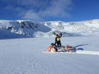
Most of the Top of the World is untracked. Riding is good up on it. I've put a couple of pictures of the area. The one picture is Jimmy from Mom's showing untracked area's. Of course it tracked up now. :becky:

AVALANCHE CONDITONS: Near Cooke City, isolated slopes have a weak layer of small facets buried under the 2 feet of new snow that fell last weekend. Many slopes do not have this weak layer and have very good stability.

With weak layers lurking on a few slopes, avalanches are possible and the avalanche danger on slopes steeper than 35 degrees is MODERATE. Less steep slopes have a LOW danger.

SAM_0032.jpg SAM_0037.jpg
 
Clear

Good morning from Cooke city. We picked up 2 inches since yesterday. The snowman is calling for warmer temps for Monday and Tuesday. We should see mid to upper 40's for those day's, with sunny skies. Wednesday we have a 40% chance of snow, with temp's in the mid 20's. Not looking good for snow at this time.

AVALANCHE CONDITONS: Lionhead area near West Yellowstone Cooke City

Overall stability has been pretty good lately. However, there have been a few small human triggered avalanches that remind us to be prepared.

In the mountains near Cooke City and West Yellowstone, buried weak layers 1-2 feet deep are the main avalanche concern. These weak layers do not exist on all slopes so it’s important to do a quick snowpack assessment before committing to steeper terrain.


With buried weak layers on some slopes and wind slabs on others, avalanches are possible and the avalanche danger is rated MODERATE on wind loaded slopes and slopes steeper than 35 degrees. All other slopes have a LOW avalanche danger.

Sorry to say, we won't be open for several days. We have a family emergency in Nebraska. We are hoping to be open Friday morning, if every thing goes good.
 
Clear and Cold

Good morning from Cooke City. We made it back last night, unfortunately we had to place Mom into Hospice for care. :brokenheart: She will be 90 in April. Our hearts and thoughts are with her. One good thing, we had great weather for the trip.
The snowman is telling us we might see snow by Sunday night till Tuesday. The chance goes from 40% to 70%.
This morning it was 13 below, we just can't shake this cold weather.

AVALANCHE CONDITIONS:
The lack of buried weak layers and absence of new snow is producing generally stable conditions. In isolated areas or extreme terrain, skiers or riders could still find unstable snow capable of producing an avalanche. On Thursday, a snowmobiler outside of Cooke City triggered a small wind slab in steep, wind loaded terrain. South of Big Sky and near West Yellowstone, sporadic layers of surface hoar and/or small facets buried 6-12 inches deep could also produce small avalanches.

Although the snowpack has a few lingering problems, human triggered avalanches are unlikely today and the avalanche danger is rated LOW. We’ll be paying close attention to a new crop of surface hoar that has now been observed in the mountains near Big Sky, West Yellowstone and Cooke City. With snow in the forecast, this weak surface layer could become our next significant avalanche problem.
 
Another day in Cooke

Its another day in Cooke city. The snowman disappointed me last night. We picked up an inch of snow. You know what that means, its still tracked up. :help: Today will be partly cloudy with temps in the mid 20's. But we might see another storm come in Monday night and Tuesday, when the chance of snow rises to 70%. With the temp's in the lower 30's.


Don't forget about the Top of the World. I know it takes some time to get up their, but its worth the wait. The riding is good and I traveled around and found lots of untracked area's. Don't forget to take a few gallons of gas with you.

AVALANCHE CONDITIONS: A period of strong winds out of the west-northwest yesterday formed fresh wind slabs in upper elevation terrain. Skiers outside of Sliver Gate triggered a wind slab that broke 50 feet wide and ran 500 vertical feet. They also observed a recent natural avalanche on Mt. Republic that appeared to be the result of recent wind loading. Today, wind slabs will continue to be the primary avalanche concern. Skiers and riders should be especially aware of this problem when traveling in steep, high consequence terrain. With more snow and wind in the forecast, wind slabs will continue to be a growing concern.

Aside from wind loaded slopes the snowpack is generally strong and stable. There is a layer of surface hoar at or just below the snow surface that will likely become a future problem. Keep this layer in mind as a snowy weather pattern moves in over the next few days.

Today, human triggered avalanches are possible on wind loaded slopes which have a MODERATE avalanche danger. Non-wind loaded slopes have a LOW avalanche danger.

Stop in and get a free cup of coffee if your wondering what to do at 5 in the morning. At that time, Terri's taking out fresh rolls.

Stop in and check out the video googles, they take just as good a picture then the Go Pro or better, and you won't loose them in the trees. :becky:
 
Lightly snowing

Good afternoon from Cooke city. A recap from yesterday, we picked up 4 inches of snow and this morning was another inch. Its still lightly snowing. The snowman is calling for 6-8 inches by tomorrow morning. By Thursday, the chance of snow drops to 40%, with highs in the upper 30's. Over the last 3 days we have seen about 10 inches in town.

AVLANCHE CONDITIONS:In the last 48 hours Cooke City has gotten over a foot of new snow measuring an inch of snow water equivalence. A snowmobiler triggered a small, 20-foot wide avalanche on a steep wind-loaded slope on the lower flanks of Crown Butte yesterday. Small avalanches like this are warning signs that bigger ones may follow as the snow piles up. Winds are blowing and drifting snow at all elevations. On some protected slopes the recent snowfalls buried a layer of feathery surface hoar crystals which will be easy to trigger. New snow, wind and a freshly buried weak layer point to a CONSIDERABLE avalanche danger on all wind-loaded terrain. Slopes without a wind-load are rated MODERATE since pockets of buried surface hoar make it possible to trigger avalanches, even in the deep powder.

Guys, follow me on Face book, (bearclawbob's) This weekend showed an improvement for selling helmets. We have a great section of helmets left. Stop by and check out what I have.
We also fill canisters for AVY packs, along with renting out the garage to work on your sled or store your sled at night in a heated garage.

The bakery had a great turn out the last couple of days. Thanks to all of you that support it. :welcome:
 
Premium Features


Back
Top