Install the app
How to install the app on iOS

Follow along with the video below to see how to install our site as a web app on your home screen.

Note: This feature may not be available in some browsers.

  • Don't miss out on all the fun! Register on our forums to post and have added features! Membership levels include a FREE membership tier.

Baker question

How much safe riding terrain is at Baker if avy conditions are high?

I'd like to hit it later this week, but don't want to drive all the way up there only to find it completely sketchy.

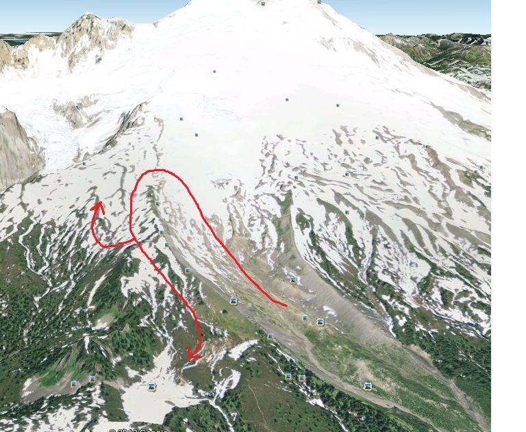
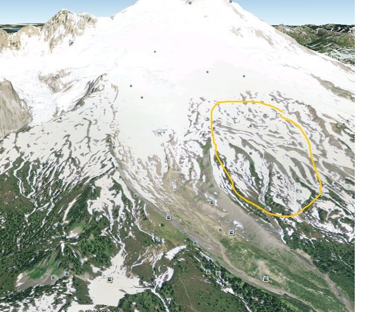
I've only been once, and rode primarily up and left (west). As I recall it seemed pretty easy to stay off dangerous aspects, however I have not been there enough to know where it comes down and how often.
 
The Meadows are flat. (before you get up by peanut knob) Thats where we stay if the conditions are bad and snowing hard. In the trees is pretty safe although avy's can be dangerous even on the trail in the right areas anywhee I guess.
 
"Check the avy forecast before you drive anywhere,"if the forecast is HIGH:face-icon-small-sho Baker is not the place to go, unless you are going to ride Schriebers meadow and up to peanut like said. Riding deep snow on Baker is awesome, riding Baker when high avy forecast:crazy:
 
Excuse my Baker geography ignorance, but peanut is the little climb at the bottom of the railroad grade? (right below the red line in pic below)

Are the lower meadows above the parking at the NF-12 / NF-13 intersection worth a darn? Seem kind of low for decent snow. When I was there on a spring ride we drove up NF-13's switch backs and parked 1/3 of the way up to Schreibers so I didn't even think there may be riding down there. Looks like they are 2-3k feet.

This is where we rode last time and getting up there in high avy danger seems quite foolish.

baker_zps091c8d49.jpg
 
Ya, correct on Peanut knob, I believe Schriebers is around 3,400 ft.? Live to ride another day.:face-icon-small-hap
 
Cool. I'll check the forcast on Wed night and decide if it's worth the drive or not. Doesn't seem worth a 2.5+ hour drive from North Bend to not get up on the mountain. Lots of meadows way closer to home.

One more question. How's this section of the mountain? When the conditions are right I'd like to explore over there. What's the easiest way to get over there, bottom, top?

baker2_zps5660487d.jpg
 
To get to the east you do the same as going to the west, head up the center then hook a left. Good riding over there, there is a point of no return if you head east enough, and it gets you close to the wilderness. Watch the bottom of the creeks as they close in pretty fast.

Lots of fun to be had.

Not sure why 2thetopp is so worried about Baker during high avy conditions, lots of mellow terrain to find and play on all over the mountain. There are lots of big climbs to stay away from as well. Just watch the long big steep climbs, and watch your terrain traps too.
 
Thanks for the info guys. I always watch the avy forecast, error on the safe side, and we always carry avy gear.

Tomorrow's storm cycle looks the warmest with the most accumulation, 17-23", NWAC says HIGH danger. Wed will bring another 5-9, but it'll start tapering off on Wed night and they are predicting CONSIDERABLE. Hopefully things wrap up earlier than expected and by Thursday the considerable rating will creep higher up the mountain.

They're calling for some sun Thurs w/ nice cold temps. Could be a winner!
 
Cool. I'll check the forcast on Wed night and decide if it's worth the drive or not. Doesn't seem worth a 2.5+ hour drive from North Bend to not get up on the mountain. Lots of meadows way closer to home.

One more question. How's this section of the mountain? When the conditions are right I'd like to explore over there. What's the easiest way to get over there, bottom, top?

baker2_zps5660487d.jpg

Hey what the site you get these killer baker maps from?
:face-icon-small-hap
 
"Cause I've been in an avy on Baker" and don't want somebody that doesn't know the mountain to do the same, just sayin'. :face-icon-small-con especially during HIGH avy conditions.

That was the north side wasn't it? If not, where were you?

I know big house has slid bad, I assume pocket lake and the area around there has slid as well. Probably the big climb from the horse corral too.

There are also a ton of terrain traps that can make small slides very dangerous as well.

Anyone have any history about big slides that have occured in the past? I note that this is a touch subject, ie past performance does not determine future results. Meaning that just because something hasn't slid in the past, doesn't mean it won't slide in the future.
 
Last edited:
Looks like a snapshot of google earth to me.

Yeah, just a print screen of google earth.

If you have not used it, definitely download it. It's free. The detail is amazing and it's a great tool to familiarize yourself with not only new areas, but your primary riding areas too.

Sometimes I'll spend hours looking at all my different riding areas and how to get to hidden stashes.
 
That was the north side wasn't it? If not, where were you?

I know big house has slid bad, I assume pocket lake and the area around there has slid as well. Probably the big climb from the horse corral too.

There are also a ton of terrain traps that can make small slides very dangerous as well.

Anyone have any history about big slides that have occured in the past? I note that this is a touch subject, ie past performance does not determine future results. Meaning that just because something hasn't slid in the past, doesn't mean it won't slide in the future.

I would also be really interesed in the common slide areas, especially ones that could run out into what is considered safe terrain.

Where is big house?

The horse corral is down below the original riding area I showed in red, NW of pocket lake right?
 
Baker is a lot of fun, the most fun you will have is on sunny days with some fresh snow witch i heard friday will be the day, peanut is a pretty safe area once you start going up and droping left or right you start to get in to more avy prone areas. i have seen a avy slide area not vary big but on the west side of peanut
 
There are also a ton of terrain traps that can make small slides very dangerous as well.

Really important point Ruffy.

I read an account of a someone right near Paradise lodge at Mt. Rainier who cut across a little bank above a gully and it broke loose completely burrying him in that gully. He was basically almost to the car, away from all the dangerous slopes, in an area most would just consider nearly flat. Luckily his buddies dug him out. His account of the situation was an eye opener because it was a tiny slope, with a very small amount of snow released, but it all piled up in that gully and got deep real quick.

I'm sure this applies to some areas of baker; cliffs and trees fall into the terrain trap category too. Getting carried through a stand of trees below the slope you are on is like going through a paper shredder. I don't know the stats, but i believe more people die from trauma than suffocation.
 
Where is big house?

The horse corral is down below the original riding area I showed in red, NW of pocket lake right?

Big house is the upper left of the yellow circle, or around there. It is a large bowl that you can keep climbing to the top of the mountain if you want to.

I believe you are right about the location of horse corral.
 
avys

That was the north side wasn't it? If not, where were you?

I know big house has slid bad, I assume pocket lake and the area around there has slid as well. Probably the big climb from the horse corral too.

There are also a ton of terrain traps that can make small slides very dangerous as well.

Anyone have any history about big slides that have occured in the past? I note that this is a touch subject, ie past performance does not determine future results. Meaning that just because something hasn't slid in the past, doesn't mean it won't slide in the future.

When you get to the point of dropping down to the horse barn or going left up near the rock out cropping, that is an area where slides happen I have seen snow bolders the size of a truck in that area.. I rode out a small avy just to the left of hood hill once in the spring. The snow depth of the avy was only two inches and I was able to steer out of it ..
 
Premium Features


Back
Top