Install the app
How to install the app on iOS

Follow along with the video below to see how to install our site as a web app on your home screen.

Note: This feature may not be available in some browsers.

  • Don't miss out on all the fun! Register on our forums to post and have added features! Membership levels include a FREE membership tier.

IF YOU GO TO THE CRATER..**WARNING**

If they continue closing any recreational areas, they need to close it for ALL user groups. No snowmobiles means no skiers. User groups need to start working with each other and not against. We all make an impact on the areas, whether hiking or snowmobiling. Our presence in the wildernes is an impact... Someone in the oval office needs to realize this.
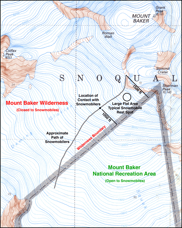
Nice pics by the way, I hope to hike up there this summer and see what it looks like, although I may not want to know what I ride on...
 
Snobi I have to disagree with your route, going around bighouse and straight up over the 16" inch crack is way safer then up the now breaking up main glacier. The cracks that are 116" inches will get you. I say this from spending a large chunk of my life climbing and backcountry skiing. I was one of them converted on a ski trip with a buddy's sled to get a bunch of us up a moutainside up icicle creek in 97. That's the year I bought my last lift ticket. I have probably spent more time living on a glacier than most. Can any one point out the exact elevation we are not supposed to cross? The crappy map I have looked at needs help. Thanks for the post and maybe some better info will come out of this.:face-icon-small-coo
 
Snobi I have to disagree with your route, going around bighouse and straight up over the 16" inch crack is way safer then up the now breaking up main glacier. The cracks that are 116" inches will get you. I say this from spending a large chunk of my life climbing and backcountry skiing. I was one of them converted on a ski trip with a buddy's sled to get a bunch of us up a moutainside up icicle creek in 97. That's the year I bought my last lift ticket. I have probably spent more time living on a glacier than most. Can any one point out the exact elevation we are not supposed to cross? The crappy map I have looked at needs help. Thanks for the post and maybe some better info will come out of this.:face-icon-small-coo

I'm not sure of the boundry's there...The hikers we ran into were very friendly. In fact there were over 50 of them up there Saturday....practicing over by the glaciers. Even met and talked to 10 of them at the Crater..And did not see any sled tracks going up by Big House at all. All the tracks were on the left side going up....which I have never taken...till Saturday. Very ominous crossing over a crevasse crack.
 
For those new to sledding or to Baker, anything much above hood hill is glacier and looks like this when the snow melts. It might be covered by 6" of snow or 60' of snow....no way to tell until it collapses.
Also a good shot looking down, you can see hood hill and the railroad grade.

This is a crevasse! If you look towards the top of the pic...this is actually what you ride on!:face-icon-small-sho:face-icon-small-sho:face-icon-small-sho

5975797604_6bfdde04b1_b.jpg
 
Bottom line is once you access the Glaciated areas on Mt Baker you are taking a risk. Once winter has set in and filled most of the crevasses in your risks have been reduced. Typically once spring shows up heading to the top becomes appealing but, IMHO May way too late to be riding to the top over the heavily crevassed areas of Mt baker on a snowmobile. Whether you know it or not you are taking a huge risk and the chance of getting killed would be at a very high level.

When you ride a snowmobile you are not with a team roped together. You have no ice axe or any serious means of self arrests. You have no way to help yourself if something collapses underneath you. I would have zero problem hiking to the top right now on a roped team with some reasonably trained people, but no way I would make the run in May or possibly even April.

Sorry don’t want to be a big bummer because I understand the allure of climbing to the top (I have done it myself), but think people should know that once you access the glaciated areas it is a different ball game.
 
I'm not sure of the boundry's there...
For as many times as it seems you go up there, this is something you should know.

BakerIllegalWildernessSnowmobilersMap-29May2011.gif


Sorry guys, but ignorance is not acceptable when it comes to knowing where you are not supposed to be riding.
 
Last edited:
I was ignorant but I am not sure I know whats legal after looking at the map

Wow,It looks like you can go almost to the top but the boundry is just before the flat spot to park your sleds.

You can't go where your sled is secure?

last time I went, I tried to park my sled perpendicular to the slope. the sled started to tip down hill. I jumped off down hill and held the sled upside down but at least not rolling down the hill. The windshield was resting on the snow. Luckily my buddy came over and helped me rite the sled and get it secure. uprite enough where it stayed put.

I am not sure what this boundry is offering sledders. drive up and risk the sled rolling down the mountain?

I wish the boundry was more apparent. I won't head up there again since I have done it twice. I only went up a second time to guide some freinds up there.

The second time is where my crank broke. Karma for having my sled out of bounds?

I am glad I went before knowing I was breaking the rules.

If I was a hiker I would like to follow the established path where the snowmobilers have gone.

The conditions are so poor, all the wind driven snow waves that your sled has to jump to get up the mountain. It has to be hard on the drivetrain, all that jumping and grabbing, jumping and grabbing.

Then theres coming down, you are glad the waves turn into speed bumps.

I am happy with the areas we can go. I just hope some of the other areas lower down are legal? I havn't studied the map but if there is a wide swatch on either side of the trough I am happy with whats available.


Ian
 
Premium Features


Back
Top