Install the app
How to install the app on iOS

Follow along with the video below to see how to install our site as a web app on your home screen.

Note: This feature may not be available in some browsers.

  • Don't miss out on all the fun! Register on our forums to post and have added features! Membership levels include a FREE membership tier.

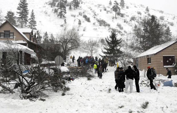
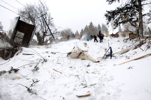
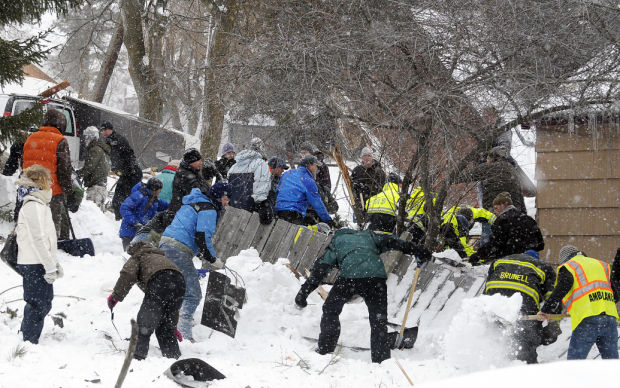
HOLY CRAP!!! Avalance comes off Mount Jumbo and down into Missoula, MT

Scott

Scott Stiegler
Staff member
Lifetime Membership
This is awful, but NOT a tragic ending for the victims.

Takes out houses and spills out onto Van Buren St.

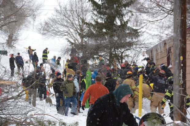
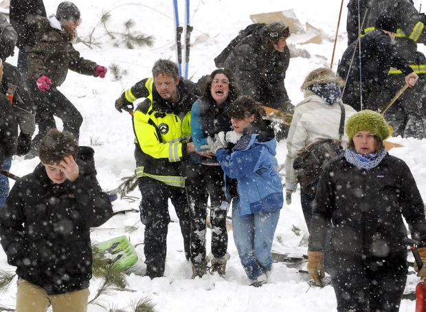
VERY LUCKY to have all 3 people pulled out alive.

The first victim, an 8 year old boy was pulled out after an hour. Listed in "fair" condition.
The elderly man was pulled out about TWO hours after the slide. Listed in "serious" condition.
The elderly woman was pulled out about THREE hours after the slide. Listed in "critical" condition.

All were taken to the hospital, which was actually on that side of town..

Some snowboarders who were up on the hill above the houses and slide path were interviewed and released by authorities.

Last avy on Mount Jumbo claimed the life of a 13 year old in 1993.


www.missoulian.com

I guess this is the mother of the 8 year old.
531167e248f1e.preview-620.jpg
 
Last edited:
West Central Montana Avalanche Center

"HIGH AVALANCHE DANGER"


http://www.snowest.com/forum/showthread.php?t=337626

Special Avalanche Information for March 1, 2014ffice:office" /><O:p></O:p>

This entry was posted on Saturday, March 1st, 2014 at 7:31 am
Categories:
Advisories<O:p></O:p>
<O:p></O:p>
High winds and continued heavy snowfall have created HIGH AVALANCHE DANGER conditions in the Rattlesnake and the southern Swan and Mission Mountains north of Missoula. This special update also includes the foothills areas close to Missoula as well as Mount Jumbo and Mount Sentinel. The avalanche danger is HIGH on any open slope steeper than 30 degrees.<O:p></O:p>
The avalanche danger in the Bitterroot mountains on wind loaded terrain steeper than 30 degrees is CONSIDERABLE. South facing slopes here also developed a sun crust earlier this week so with east to north winds expect these aspects to get loaded. <O:p></O:p>
AVALANCHE ACCIDENT<O:p></O:p>
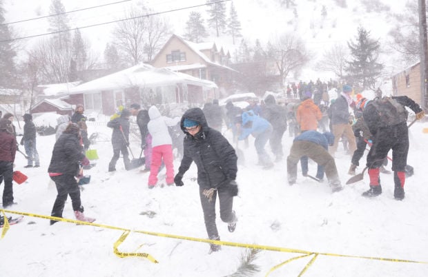
Strong east winds and heavy snowfall associated with a blizzard in the Missoula valley have created very dangerous avalanche conditions on Mount Jumbo, Mount Sentinel and other steep open slopes close to Missoula. A large slab avalanche was triggered by a snowboarder near the top of Mount Jumbo yesterday afternoon. The avalanche ran to the valley floor, destroyed two homes and buried 3 people. A large rescue effort consisting of local first response teams, law enforcement, Search and Rescue personnel and at least 100 nearby residents quickly mobilized to assist with search efforts. All 3 victims were found alive and transported to local hospitals.<O:p></O:p>
The City of Missoula Police and Fire Departments are conducting an investigation into this tragic event.<O:p></O:p>
Our thoughts are with them and their families hoping for a speedy and full recovery. Many thanks to everyone involved in this complicated rescue.<O:p></O:p>
<O:p></O:p>
Weather and Snow<O:p></O:p>

Warm temperatures and sun Tuesday and Wednesday created a hard ice crust which is now a perfect bed surface for avalanches. Blizzard conditions in the valley have formed sensitive storm slabs and wind slabs on a variety of aspects. Any open terrain steeper than 30 degrees that has been recently loaded should be avoided. Many people reported to us Friday that they triggered wind slabs and experienced collapse and fracture propagation in areas loaded by the wind on Mount Sentinel.<O:p></O:p>
It has been many years since Missoula has seen a full-on blizzard with this much snow. High winds are expected again today and will continue to load these low elevation slopes. Please respect these conditions and avoid Mount Jumbo and the steeper slopes of Mount Sentinel for a few days.<O:p></O:p>
The backcountry of the Bitterroot Mountains has not received the heavy snowfall seen in the Rattlesnake or Missoula valley. Mountain winds have been fairly calm until late yesterday when east winds reached the higher elevations. This morning on Point Six, east winds are topping out at 61 mph! The temperature is -21 for a wind chill value in the negative 60 degree range. I would expect to see high ridgetop winds throughout the Bitterroot today as this arctic air takes hold.<O:p></O:p>
Weather and Avalanche Forecast<O:p></O:p>

The Weather Service is forecasting east winds of up to 50 mph to continue thru this morning. The heavy snow has moved out of the area but we can expect ANOTHER round of heavy snowfall starting Sunday night. This storm may be much wetter and warmer than what we current have which will only make avalanche danger conditions worsen.<O:p></O:p>
The next regular avalanche advisory will be issued by Dudley Tuesday morning however we will post information updates as needed.<O:p></O:p>
<O:p></O:p>

<O:p></O:p>
This information is the sole responsibility of the Forest Service and does not apply to operating ski areas. The avalanche danger rating expires at midnight tonight but you can use the information we provide to help you make more informed decisions regarding travel in avalanche terrain for the next few days.

Our advisory area includes the Bitterroot Mountains from Lost Trail Pass North to Hoodoo Pass, the Rattlesnake Mountains and the Southern Swan and Mission Mountains near Seeley Lake. Avalanche information for the Lookout Pass/St. Regis Basin is available from the
Idaho Panhandle Avalanche Center. <O:p></O:p>


--

West Central Montana Avalanche Center
Lolo National Forest
Bldg. 24a Fort Missoula Rd.
Missoula, MT 59804
406-329-3752 cell 406-370-3371
info@missoulaavalanche.org<O:p></O:p>
<!-- / message --><!-- sig -->
 
Unreal!! Bet those homeowners will get nervous from now on when it snows. Hope the people injured pull through OK.
 
Yes, but they are thinking it was possibly human triggered.

I have no idea how liability or blame can be placed on the snowboarders they interviewed, even if they determined that it WAS human caused.

No doubt. Obviously it was a slope that should have been surveyed before any building permits were issued, and/or maintained by some level of the gov.
 
No doubt. Obviously it was a slope that should have been surveyed before any building permits were issued, and/or maintained by some level of the gov.

We lost our lake house to flooding.
Always a possibility living near water, which is why we had flood coverage.

It should not be a complete surprise to have avy damage when you live at the base of a mountain in snow country. Again, it's why we carry insurance.

We certainly do not need any type of government intervention/protection.
They have enough things to F up right now.
 
That neighborhood was built before they knew what avalanches were.

Most winters that thing never has more than 6" of snow for a couple days at a time.


Yesterday an avalanche came off a different hill along Interstate 90 and covered the west bound Orange Street exit in Missoula.
 
Premium Features


Back
Top