Install the app
How to install the app on iOS

Follow along with the video below to see how to install our site as a web app on your home screen.

Note: This feature may not be available in some browsers.

  • Don't miss out on all the fun! Register on our forums to post and have added features! Membership levels include a FREE membership tier.

Grand Mesa (Fire lookout Station)

A

Adobe-Al

Well-known member
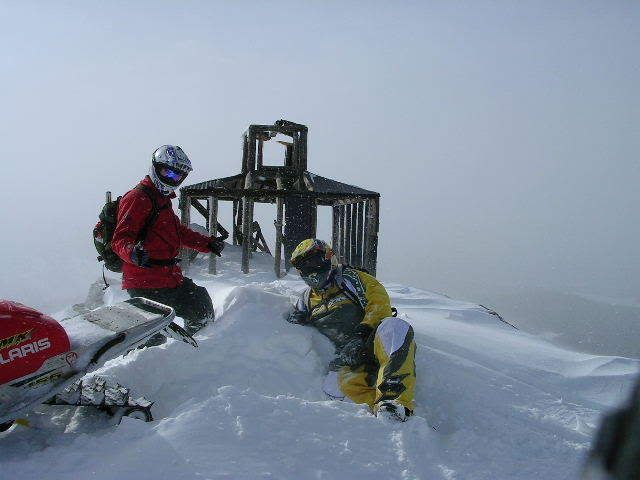
A few years ago I was on the Mesa riding with my wife when we ran into a guy that showed us some riding northeast of the SP trail(I THINK). The only thing about how to get there that I can remember is that we could see a old fire look out station to the east of us, on a high mountain. He said some years you can ride up to it. Can anyone tell me where and how to get there again?
 
The old fire lookout is on Leon Peak. When the Forest Service use to man the lookout they rode horses or mules up to it. There is no road. You can sled up to it, but its a little difficult to describe how since for the most part you make your own trail.
 
That's the one that was hit by lightning and is partially burned right?
 
Fire Lookout

I couldn't tell if it was burnt or not. The guy we where with said, after it was built a range stayed in it only one day. He said the lightning was to crazy for anyone to stay up there. Thanks for the info about the peak I'll try to find my way back again this year.
 
Here ya go...

Here's a pic from the lookout last winter. Leon Peak is the highest point on the western Grand Mesa, and it's awesome up there.

GrandMesa2-16-08038.jpg


Here's a pic from this Saturday, Leon Peak is the high point in the background.

DSCN2518.jpg


There needs to be A LOT of snow to get up there. At least 70-80" base. It's all rock, and most of the boulders are the size of suburbans...I've hiked it in the summer. The easiest way to get up there in winter is from the upper Finney Cut lake. Go west up the gladed ravine to a nice flat meadow. Then climb up to the base of the cliffs you see to the south(you can see them in the second pic above, it will be obvious). Then you've got to sidehill back (south/east) along the cliffs, to a steep draw that leads straight up. Go up it. Once you get up the initial steep part, veer right and up onto a large flat. From here, go as far west on the flat as you can, and then a short steep climb to the peak. All this will make sense when you're there. I know there is a way up from the front (south/west) side, but havent' found it yet. Plan on doing that this winter. Hope this helps, be careful over there if you go. Lots of Avy potential, so make sure you're checking the conditions and everybody in your group has avalanche gear and knows how to use them. :beer;
 
I went up there a couple of years ago in Febuary and there are a couple of different ways to get up there. The only way we found a way was, we found a group of people who have been up there and they showed us a way up through the trees. Like you've heard you need alot of snow to get up there becuase of the winds blowing the snow off uncovering alot of rocks. Overall it is pretty diffucult to get up there but its worth the effort!!
 
Great Pic's

We where in a play area to north(miles)of that picture. Do you know the name of the lake in your pic. Thanks for the info I will start studing my maps.

It sounds like we might get that big storm we need to kick this season into gear. From what I hear and see this next weekends storm could be BIG! YA HOO!!
 
Yep - that's the one we were at. It is a fun ride up there, and a great view!

I have no idea how to get there, the guys I ride with know that area a lot better than I do - so I just follow them and try not to get stuck :beer;
 
Premium Features


Back
Top