Install the app
How to install the app on iOS

Follow along with the video below to see how to install our site as a web app on your home screen.

Note: This feature may not be available in some browsers.

  • Don't miss out on all the fun! Register on our forums to post and have added features! Membership levels include a FREE membership tier.

Wolf Creek Help

B

bradburck

Well-known member
So we're taking a group of 4 to WC this weekend for an adventure I'm sure... and we've got no clue where we're going... any help out there guys?? We just wanna ride... leaving Friday night and staying in South Fork I believe.. unless someone has a better idea.. then up early Saturday to figure out a place to ride... Thanks for the help guys.. stay safe this weekend.. avy's will be out in force...
 
Last edited:
Tucker Ponds...or up by the pass...parking lots on the side of the highway
 
Last edited:
Don't forget about Irwin or the Mesa, they got slammed pretty good too :D
 
  • Like
Reactions: BTP
Factoring in traffic from southern Denver (Parker) wouldn't the Mesa be about the same amount of time??

Just curious:)

Man, my little 600 is gunna get a work out this weekend:):):)

I LOVE SNOW!!!
 
From Denver WC will be at 6 hours or a little more depending on where you came from.

Top of WC typically gets the most snow.
 
if i have a new sled by this weekend i will be up on wolf creek with some friend and we could show you around we ride out of the parking lot right on top of the pass
 
tucker ponds

hit the TP TH and go up the road to the top of the mesa, i dont have the map in front of me but i think it is wolf mtn?? nice high 10500 flat play area with a port o potty and all.

hit this from the sf side. get yourself a map and you will see what i mean.

dont go up to the top of the pass as tempting as that might be, its all hammer heads and there really is not alot to choose from up there.
 
Help

So we're taking a group of 4 to WC this weekend for an adventure I'm sure... and we've got no clue where we're going... any help out there guys?? We just wanna ride... leaving Friday night and staying in South Fork I believe.. unless someone has a better idea.. then up early Saturday to figure out a place to ride... Thanks for the help guys.. stay safe this weekend.. avy's will be out in force...

I will tell you, no bull, Tucker Ponds is hard to navigate. Most who don't know where there going end right back on park creek road ( the road to summitville mine). Since you will end there, makes more since to use park creek TH. But as of right now the pass is closed. Hopefully the trail heads will get plowed open so we can park by this weekend, as far as park creek and tucker.

logger
 
102 mph gust

news just said they recorded a 102mph gust on top of the pass yesterday.

also, x2 on the navigation of this area. not for rookies, lots of tangents to go off on and get turned around on. if it is low visibility, you better know how to read a map (topo) and have a good gps

Pass is closed currently, watch for avys
 
Maps & trail conditions are up on the new CSA website, www.snowmobilecolo.com click on South Fork Powder Busters under trail reports and maps. Grooming reports are updated by EOD each Thursday.

http://www.snowmobilecolo.com/content.aspx?page_id=1980&club_id=45117#search_results

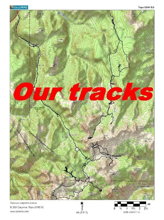
Some tracks from two days of riding last year ...
WolfCreekN.jpg
 
Last edited:
I will tell you, no bull, Tucker Ponds is hard to navigate. Most who don't know where there going end right back on park creek road ( the road to summitville mine). Since you will end there, makes more since to use park creek TH. But as of right now the pass is closed. Hopefully the trail heads will get plowed open so we can park by this weekend, as far as park creek and tucker.

logger

Park creek is closed until the first of the year. EPA is rebuilding the second bridge.
 
Thanks

Thanks for all the help guys... if anyone makes it up before us we'd love some pics! It's just an adventure for us.. I think we may just park on the side of hte road and hammer... we've got no clue where we are going... but at least a bit of common sense and plenty of safety equipment. Hope to see many of you guys up there. maybe you can help me get unstuck! HA!! Drive safe and keep your eyes pealed for avy danger!!
 
Park Creek road closed

Dizzle is correct, I talked to the project manager today. Park Creek will be closed Dec.15 to Jan 1. Although the closure date has not been reached, PM said the road is plowed down to the dirt about 2 miles in. At this point there is no turn around. Besides there is a cat motor grader parked across the road, no way around.
 
So it sounds like the best place to unload would be #6 on the map from above given Park Creek (#3) is closed...

PB#6 Pass Creek Trail/Tucker Ponds FSR# 390

Is this correct???

Thanks again guys,
Ryan
 
Rode up that direction yesterday. STUCK pretty much all day. Jump off the sled and I was sinking to the dirt, snow up to my belly button.(42 inches, yes I measured when I got home) Very nice that we got a big storm, sucks that there is no base under it. We were trenching really bad all day and dug to the dirt on most stucks. No way of knowing when you're gonna hit a rock or a stump until you already have. Also, as of yesterday the parking lot to tucker ponds wasn't plowed. Great start, but we really need more snow.

Thank God for my Harmon highlift jack! Without it I would probably still be stuck up there, on flat ground.
 
Last edited:
Premium Features


Back
Top