Install the app
How to install the app on iOS

Follow along with the video below to see how to install our site as a web app on your home screen.

Note: This feature may not be available in some browsers.

  • Don't miss out on all the fun! Register on our forums to post and have added features! Membership levels include a FREE membership tier.

Let's talk about avalanches, hazards and snowbiking

Caltopo is only as accurate as the topographic data that it is based on. 10 METER grid data is common. Think about how terrain can change in 10 meters especially if it is out of date survey. threading the needle using that map data is dangerous. Silverton avalanche from last year is a good example of that.
 
What caltopo doesn't take into consideration is slope shape (convex, concave, bowl, ridge, etc); and vegetation - i.e. are there enough trees to be anchoring / disrupting the slab/weak layer to where it's not a problem.
I agree, Cal Too is not accurate enough to solely plan a route with. I do think it is a great tool for looking at unfamiliar terrain.

As for trees anchoring a slope, I use the rule that "if the trees are spaced apart enough to ski then the slope can still slide".

Thanks again for the great discussion.
 
Thanks for sharing... scary stuff!

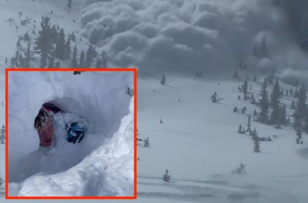
Remember, it's not always the slopes you're on, but can also be the slopes you're underneath. This is especially true this year, as most western states are dealing with a Persistent Avalanche Problem and Remote Triggers are real and happening.

How do you know if you are clear of overhead hazard? Measuring your Alpha Angles is a relatively quick and easy way to get an idea if you are exposed to overhead hazard while ripping around the flats. Alpha angles can vary depending on the type of avalanche problem you're dealing with, but if you just remember 20 degrees or less, that will keep safe from nearly all overhead avalanche hazards.

How do you measure Alpha Angles? There are sever tools you can use such as a compass with an inclinometer or a specific slope angle tool like BCA sells. Personally, I like to use my phone. On my iPhone, in the Utilities App I select the Level function, then holding my phone on edge I sight down the long edge from my position to either the top of the peak/ridge/bowl or where I think the start zone of an avalanche might be. This will give me a number on the screen and if I'm seeing anything greater than 20* then I know that I'm potentially exposed to an avalanche on that slope.

This doesn't have to be cumbersome and take a lot time. When I'm out for a day with a group, we have decided ahead of time what type of terrain is appropriate for the current conditions (non avalanche, simple, challenging, or complex). We've also picked a few spots to stop, regroup and reassess conditions and check in with each rider. Braaaping into a new zone is a good time to do this. If you're dealing with a Persistent Slab problem and the local avalanche bulletin is warming of remote triggers, I'll pull out my phone, shoot a couple alpha angles and set some boundaries on where we think it's safe to ride and terrain that should be avoided.

Read the local forecast. Know what to look for. Know what to avoid. Communicate with your group. Play safe and come home at the end of the day! I'm huge proponent of avalanche education, not only because I'm an instructor, but also because I believe that you'll never achieve your potential as a rider if you know nothing about winter mountains and avalanches.

If you're near Central Idaho I've got another Motorized Level 1 Course coming up Feb 5-7.

We've got a storm rolling into our zone this week (finally!!!). We're currently dealing with a stubborn Persistent Slab problem with a buried facet layer anywhere from 40-80cm down from the snow surface. We've also noted widespread surface hoar on nearly all aspects and elevations. The potential is there. Things could get pretty real here by the end of the week if we receive the 1.5-2' of snow they are forecasting!
Clicked that link, surprised they sell them for $25! Even more impressed, the 2 day awareness course I took here in Gallatin gave them away to everyone who showed up and it has been in my jacket since. Super useful tool any time I think a slope might even remotely be sketchy steepness and it really helped me to calibrate my internal measurement of what a safe angle is on sight.
 
Far too many deaths in the past two weeks. One snowmobiler yesterday in Washington. Please be safe. Even "experts" are getting caught in slides. Persistent slabs under lots of new snow is an extremely dangerous condition.
 
Feb 6 Saturday morning in Western Montana, we go to breakfast at 7 and discuss the weekend riding.
1. Its snowing like crazy out side ?
2. Not a tough decision to make, Stay HOME!!!!


Feb 7. 7 am phone conference, windblowing like crazy, new fluffy snow building and making windloaded East facing slopes, temp dropoping........easy lookout the window decision...........StayHome.

45 years of motorized snow recreatrion you learn a few things, a look out the window ?

Big weekend for avalanche deaths, one closeby here in Montana, nothing but sympathy for their families, so sad.
 
Far too many deaths in the past two weeks. One snowmobiler yesterday in Washington. Please be safe. Even "experts" are getting caught in slides. Persistent slabs under lots of new snow is an extremely dangerous condition.

It was a snowbiker, with a deployed airbag. Buried 4 feet down, near his partner who was only partially buried. The partner self extracted, attempted a search, then went out to get help. The full report isn't out, but NWAC did put out a quick 1 minute video with a run down.

The core of my riding group did an avalanche rescue course with Mike Duffy 3 weeks ago about 1.5 air miles from where that avalanche happened.
 
You can not play around with a buried Persistent Weak Layer (i.e. faceted grains or surface hoar). These types of weak layers can "persist" and cause avalanches time and time again over a long duration. They are unpredictable. Your only sane choice when dealing with these buried weak layers is to stay off of and out from underneath slopes that are 30˚ or steeper. This stuff will bite you long after you think there's nothing going on. This is the case this year here in Utah and things will continue to be dangerous for some time to come.
 
Your best and easiest defense is to learn how to judge slope angles. To do this, go out and start guessing what the steepness of various slopes are and then measure the slopes. I use an app called Theodilite but there are many out there. Choose one where you can sight down or up the slope as well as hold the phone sideways on a hill for a reading. Do this regularly and eventually you will start getting pretty good at estimating. Most importantly, you'll be able to recognize slopes that are steep enough to avalanche.

You don't have to stay home when it's puking out and the avalanche danger is high. You just need to avoid steep slopes.
 
Your best and easiest defense is to learn how to judge slope angles. To do this, go out and start guessing what the steepness of various slopes are and then measure the slopes. I use an app called Theodilite but there are many out there. Choose one where you can sight down or up the slope as well as hold the phone sideways on a hill for a reading. Do this regularly and eventually you will start getting pretty good at estimating. Most import


Looks like we need to talk about remote triggering and overhead hazard.

Things have been mellow here in coastal BC but we are going through a week of artic outflows. Next big snowfall will likely get electric.
 
I came from BC skiing background, and found my approach to avy danger a bit different than a lot in the moto community. The idea that just staying home on "high risk" days and then hitting exposed terrain on other days seems to run strong in the moto community. I usually ride with the expectation that anything that can slide will, unless it just did. So I try to minimize my risk and line choices. Being that I do ride in the steep terrain I know I am usually taking a risk when I ride in general. Below... I was riding on top of a spine and dipped a hair below the top in dense trees. The terrain quickly got vertical with a short open section. I stopped to take a look and found I was at the very top of the opening, so I made a quick ski cut across, and it slid below me. About a 2ft crown, a good ways into very steep dense trees below. Had I been a few yards lower I would not have cut across, as I would have been on a bad ride. A lot of times skiing in backcountry we would be hitting steep chutes. We tested them with ski cuts, sometimes setting them off.
A7300208-Pano-2.jpg
 
We have had more than a week of cold and snow event, nothing major, but Sat morning we will find " blower powder " and worse the higher you go. The snow out here right now in our riding area will be accompanied by poor flat light, periods of " white out " and snow your 174 blower skidoo will not go through on flat ground. So besides the obvious avalanche danger, these conditons produce the rescue missions ( two so far this week ) where 10 guys risk their own lives to try and find the pilgrims that dropped into that draw, disoriented, mid afternoon, should have kept the tailights on the pickup in sight all day.

So.........don't be stupid, nice days will come along, the snow will settle, avalanche danger may be extreme for another month if not the rest of the year, nothing wrong with going back home for lunch at 11. This ain't the superbowl.
 
Thank you to all the experts helping out it, it's great to have access to this info!

How does past traffic factor in to evaluating a slope? A lot of hill climbs we all play on see traffic all year and I would think that slide potential is greatly reduced when a hill is tracked up but is that always the case?


Compaction definitely helps but it isn't a simple answer.
It really depends on the avalanche problem.
If the entire slope that you climb gets completely compacted regularly then you could certainly feel better about it than a similar non compacted slope. But even that compacted slope with very warm temps in the spring and an isothermic snowpack your benefits are gone again.
 
"it depends" is often the answer. It is the thin spots that usually are the trigger. Or the wind loaded spots that look great but are ready to pop.

I read incident reports all the time about spots that were ridden the days before without issue and slide the next day. Some like in Utah they put 15 tracks on it before it killed 4 people.
 
Premium Features


Back
Top