Install the app
How to install the app on iOS

Follow along with the video below to see how to install our site as a web app on your home screen.

Note: This feature may not be available in some browsers.

  • Don't miss out on all the fun! Register on our forums to post and have added features! Membership levels include a FREE membership tier.

Storm 12-13 Jan Tuesday - Wednesday

donbrown

Well-known member
Lifetime Membership
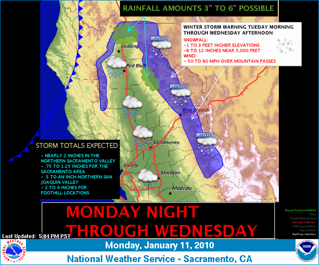
Probabilities of forecast accuracy

70 % chance Mammoth expects 12-18 inches of snow at 8000 feet 12-13 dropping to 6000 feet Wed

50 % chance Los Angeles 3-6 inches same dates levels to 7000 feet

90 % chance Tahoe Rain Snow Mon - Wed 10 PM Most storm Tuesday am and late pm 6in to a foot more than Mammoth

90% chance Susanville levels to 5500 feet. Same type amounts at Tahoe area.

Storm will be warm so above freezing at 7000 feet afternoon and below at night.


Starting 19 January for 10 plus days El Nino socal rains with snow at high elevations.


Sherman pass may get some finally?

Can we have people ring out to see if this happens.

I sure would like to ride on some nice snow for MLK.
 
Last edited:
Special Weather Statement
SPECIAL WEATHER STATEMENT
NATIONAL WEATHER SERVICE RENO NV
404 PM PST SUN JAN 10 2010

CAZ070>073-NVZ001>005-111300-
SURPRISE VALLEY CALIFORNIA-LASSEN-EASTERN PLUMAS-
EASTERN SIERRA COUNTIES-GREATER LAKE TAHOE AREA-MONO-
MINERAL AND SOUTHERN LYON COUNTIES-GREATER RENO-CARSON CITY-
MINDEN AREA-WESTERN NEVADA BASIN AND RANGE INCLUDING PYRAMID LAKE-
NORTHERN WASHOE COUNTY-
INCLUDING THE CITIES OF...CEDARVILLE...EAGLEVILLE...
FORT BIDWELL...PORTOLA...SUSANVILLE...WESTWOOD...SIERRAVILLE...
LOYALTON...SOUTH LAKE TAHOE...TAHOE CITY...TRUCKEE...
MARKLEEVILLE...BRIDGEPORT...COLEVILLE...LEE VINING...
MAMMOTH LAKES...HAWTHORNE...YERINGTON...SMITH VALLEY...MINA...
SCHURZ...GLENBROOK...INCLINE VILLAGE...SPARKS...VERDI...
GARDNERVILLE...FERNLEY...FALLON...LOVELOCK...SILVER SPRINGS...
NIXON...IMLAY...EMPIRE...GERLACH
404 PM PST SUN JAN 10 2010

...AN ACTIVE PERIOD WITH MORE SIGNIFICANT SYSTEMS STARTING TUESDAY...

STRONG INVERSIONS AND COPIOUS MOISTURE WILL TRAP LOW CLOUDS AND FOG
IN THE VALLEYS THROUGH MONDAY. AN APPROACHING DISTURBANCE MONDAY
NIGHT AND TUESDAY WILL INCREASE WINDS AND SCOUR OUT THE FOG AND CLOUDS.

TWO DISTURBANCES...ONE TUESDAY AND A SECOND TUESDAY NIGHT AND WEDNESDAY...
WILL BRING GUSTY WINDS ALONG WITH MOUNTAIN SNOW AND MAINLY RAIN IN
THE LOWER VALLEYS. SIGNIFICANT SNOWFALL IS POSSIBLE IN THE SIERRA
TUESDAY AND WEDNESDAY...WHILE WIND GUSTS TO 45 MPH AND LOCALLY TO
55 MPH WILL BE POSSIBLE TUESDAY FOR THE SIERRA AND WESTERN NEVADA
.

FOLLOWING A RIDGE OF HIGH PRESSURE THURSDAY AND FRIDAY...THE DOOR
WILL OPEN FOR SIGNIFICANT AND PROLONGED PRECIPITATION IN THE SIERRA
INTO THE FOLLOWING WEEK OF 17 JANUARY.


$$

SNYDER

HTTP://WEATHER.GOV/RENO
 
Monday, January 11, 2010 9:00:41 AM


"UPCOMING MODERATE STORM WILL BRING A 1-2 PUNCH TO THE EASTERN SIERRA. POSSIBLE 12 TO 18 INCHES OVER UPPER ELEVATIONS BY WEDNESDAY PM.....1ST SYSTEM HITS MAINLY TUESDAY PM AND THE WEDNESDAY SYSTEM, THE MORNING INTO THE EARLY PM HOURS.....THEN A BREAK THURSDAY INTO FRIDAY FOLLOWED BY A UNSETTLED WEEKEND.....WITH POSSIBLE SNOW SHOWERS OR LIGHT SNOW"

NEXT WEATHER SYSTEM PLOWING THROUGH THE EASTERN PACIFIC IS PUSHING THE WESTERN UPPER RIDGE EASTWARD....LEADING BAND OF THE 700MB RH IS FORECASTED TO REACH THE MAMMOTH SIERRA BEFORE SUNRISE TUESDAY MORNING. TUESDAY THROUGH WEDNESDAY QPF FOR THE UPPER MOUNTAIN ABOUT 1.5 INCHES.
SO DWEEB'S UPDATED BEST GUESS AT THE MOMENT IS 12 TO 18 INCHES OF NEW SNOW POSSIBLE BY LATE WEDNESDAY AFTERNOON AT THE MAIN LODGE. AMOUNTS FOR THE SNOW PUSHER'S PROBABLY LESS THEN A FOOT IN TOWN AS THE STORM WILL BEGIN FAIRLY WARM WITH SNOW LEVELS BEGINNING ABOUT 7500 FEET THEN LOWERING TUESDAY NIGHT INTO WEDNESDAY AM TO 6000 FT
.

LATEST OPERATIONAL GFS HAS UPPER JET PRESIDENTS WEEK TAKING AIM ON SOUTHERN CA.....GOT SANDBAGS?.....FOR THE 19TH AND BEYOND?

THE DWEEBER..............
 
make_img.png
 
Last edited:
Area forecast discussion national weather service san joaquin valley - hanford ca 944 pm pst mon jan 11 2010 .synopsis... High and mid level clouds are moving in ahead of a weather disturbance from the pacific expected to hit central california on tuesday. Through the day tuesday temperatures are expected to warm further due to southerly winds ahead of the system. This system could bring light to moderate rain from late tuesday afternoon through wednesday morning to the san joaquin valley and significant snow to the sierra nevada with the heaviest amounts from yosemite to kings canyon. Otherwise expect high pressure to return with dry conditions for the remainder of the week. && .discussion...southerly flow ahead of an approaching storm system finally cleared out the low stratus from the valley late this afternoon. Though warmer today...it was not quite as much as expected and have adjusted tonight/s min temps down a little as some current temps were nearing fcstd lows. A tightened south to north pressure gradient has resulted in some gusty winds through passes in the tehachapi mountains. The grapevine chp aprs site has been gusting around 40 mph this evening and have a special weather statement out for the travel concerns. Models still advertising a good precip event beginning tuesday aftn. The first of a one two punch of short wave troughs moves over north/cntrl ca tuesday aftn followed by the stronger trough late tuesday night/wed morning. Model qpf is quite varied with the nam the most bullish...but a compromise matches up well with the latest rfc guidance. The sj valley from merced to fresno county looks to get from a half inch to as much as one inch of rainfall...tapering off to around a tenth of an inch over kern county. One to two inches qpf for the southern sierra from tuolumne to fresno county...tapering to up to one inch across the tulare county mountains.
a winter storm warning has been issued for the southern sierra from yosemite to kings canyon from 4 pm tues to 4 pm wed where up to 2 feet of snowfall is possible especially around yosemite national park. Opted for a winter weather advisory across the tulare county portion of the so sierra for the same time frame with snowfall amounts up to 10 inches expected.
updated grids and associated products have been issued. &&
 
Same forecast.

12-18 inches mammoth
1-3 feet northern California
10-16 inches Sherman pass
1-6 inches Los Angeles

Major southern approaching storms coming 18 thru end of January. Will hit California but no sure where because a cyclone by Japan is creating multiple low pressure systems (over 6 which allot) and they will head to the USA. When a low pressure system goes from Marin County to SanDiego County it will pull the cold jet stream and the warm Hawaaian moisture together and create percipitation.​

Monday, January 11, 2010 5:46:16 PM


"UPCOMING MODERATE STORM WILL BRING A 1-2 PUNCH TO THE EASTERN SIERRA. POSSIBLE 12 TO 18 INCHES OVER UPPER ELEVATIONS BY WEDNESDAY PM.....1ST SYSTEM HITS MAINLY TUESDAY PM AND THE WEDNESDAY SYSTEM, THE MORNING INTO THE EARLY PM HOURS.....THEN A BREAK THURSDAY INTO FRIDAY FOLLOWED BY A UNSETTLED WEEKEND.....WITH POSSIBLE SNOW SHOWERS OR LIGHT SNOW"

NEXT WEATHER SYSTEM PLOWING THROUGH THE EASTERN PACIFIC IS PUSHING THE WESTERN UPPER RIDGE EASTWARD....LEADING BAND OF THE 700MB RH IS FORECASTED TO REACH THE MAMMOTH SIERRA BEFORE SUNRISE TUESDAY MORNING. TUESDAY THROUGH WEDNESDAY QPF FOR THE UPPER MOUNTAIN ABOUT 1.3 INCHES. SO DWEEB'S UPDATED BEST GUESS AT THE MOMENT IS 12 TO 18 INCHES OF NEW SNOW POSSIBLE BY LATE WEDNESDAY AFTERNOON AT THE MAIN LODGE. AMOUNTS FOR THE SNOW PUSHER'S PROBABLY LESS THEN A FOOT IN TOWN AS THE STORM WILL BEGIN FAIRLY WARM WITH SNOW LEVELS BEGINNING ABOUT 7500-8000 FEET THEN LOWERING TUESDAY NIGHT INTO WEDNESDAY AM TO 6000 FT.

LATEST OPERATIONAL GFS HAS UPPER JET MLK WEEK TAKING AIM ON SOUTHERN CA.....GOT SANDBAGS?.....FOR THE 18TH THROUGH THE WEEKEND AND QUITE POSSIBLY BEYOND.........
 
Last edited:
Wednesday, January 13, 2010 8:36:34 AM


LAST NIGHT STORM DROPS 15 INCHES OF SNOW ON MAMMOTH MOUNTAIN....AND 10 INCHES AT THE VILLAGE AT MAMMOTH. IN THAT THE WX FRONT HAS NOW MOVED ON TO THE EAST, POST FRONTAL INSTABILITY AND SNOW SHOWERS WILL KEEP THE SNOW GOING IN SHOWERS THIS MORNING. HOWEVER, A ONLY A FEW MORE INCHES OF SNOW IS EXPECTED THIS MORNING. AND....IT SHOULD BE PRETTY MUCH OVER WITH BY NOON TODAY.....HIGHS TODAY IN MAMMOTH WILL BE IN THE 20S OVER THE UPPER MOUNTAIN AND IN THE 30S IN THE TOWN. IT WILL BE WINDY OVER THE CREST THIS AFTERNOON WITH A CHANCE OF LINGERING SNOW SHOWERS.

HIGH PRESSURE RIDGING WILL MAKE ITS WAY BACK INTO OUR AREA THIS AFTERNOON EXPECT PARTLY CLOUDY SKIES THROUGH FRIDAY NIGHT.

THE NEXT SPLITTING WX SYSTEM WILL MOVE INTO MAMMOTH SATURDAY, BRINGING MAINLY LIGHT TO POSSIBLY MODERATE AMOUNTS OF SNOW DURING THE DAY. (STAY TUNED TO AN UPDATE ON THAT ONE)

OUTLOOK:

LARGE SCALE PATTERN OVER THE PACIFIC STILL SHOWS THE EL NINO ENHANCED....EXTENDED ASIAN UPPER JET JUST OFF THE WEST COAST. NEXT WEEK'S WX, I.E.(WEATHER) WILL BRING QUITE A LOT OF SNOW!


DR HOWARD AND THE DWEEBS..............................:-)
 
http://tahoeweatherdiscussion.com/

Snow levels ruined the forecast at lake level, but the resorts did pretty good. Check out the resort totals tab. Most of them getting the lower end of the forecast with an Tahoe area wide average of 11-18 inches, but still plenty and it was thick so a good base builder. Not sure what happened at Sugar Bowl? Two heavier bands set up in the evening just North of the lake and you can see the higher totals in the resorts that got the band like Squaw, Alpine, and Northstar. Got around 6 inches at my house which is on a small hill on the North end of the lake at around 6500 ft. By the time I got down the hill to the lake there was about 2 inches, so probaby a two day total of 4 inches at the lake. Snow levels stayed just above lake level until the very end of the storm. Most of the snow fell with the frontal band which came through between 2 and 6 a.m. Light scattered snow showers could add light accumulations in spots this morning.

Ridge quickly moves in with highs in the 40’s by tomorrow and near 50 on Friday with plenty of sun. The pattern change begins to take shape on Saturday. The next storm is the first in a long train of about 6 storms in a 10 day period. The first storm on Saturday will fall apart as its job is to move the ridge out of the way opening the storm door, and to moisten the atmosphere.

First big storm arrives Sunday night. Early for snow totals but at least 2 feet looks to be possible for the first storm Sunday into Monday. Not much of a break before the second storm for Tues/Wed, and then the third storm for Thurs/Fri. That will be followed by the fourth storm on Sun/Mon and the fifth on the Tuesday the 26th. It is going to be a snowy ten days. Just going to have to watch the exact track of each storm for snowfall amounts, but either way we will get snow from each storm. The best part is that all of the storms will be cold with snow levels below lake level, so significant accumulations all the way down to lake level.

The MJO will be slowly wandering into the Western Pacific and strengthening over the next two weeks. Meanwhile the NAO is not forecasted to go strong negative anytime soon forming any blocks. There may be a bit more space between storms going towards the end of the month but teleconnection forecasts point towards the storminess continuing into February.

Stay tuned the next few days as the exact storm tracks and snow totals of next weeks storms become more clear. BA
 
Premium Features


Back
Top