
Can someone tell me how to get to Pearl Pass from Cement Creek. I've been in Cement Creek from the Taylor Park side and now I need to figure how to get to Pearl Pass from there. I know it can be done I just do not know how yet, can anyone help me?
Install the app
How to install the app on iOS
Follow along with the video below to see how to install our site as a web app on your home screen.
Note: This feature may not be available in some browsers.
You are using an out of date browser. It may not display this or other websites correctly.
You should upgrade or use an alternative browser.
You should upgrade or use an alternative browser.
Pearl Pass???
- Thread starter arcticcat38
- Start date
Avy Danger
I believe Pearl Pass is a high avalanche danger area. I have been told its a bad idea to ride it.
Anybody else have any experience in this area?
.
I believe Pearl Pass is a high avalanche danger area. I have been told its a bad idea to ride it.
Anybody else have any experience in this area?
.
I believe Pearl Pass is a high avalanche danger area. I have been told its a bad idea to ride it.
Anybody else have any experience in this area?
.
I loked at a mining claim up pretty close to pearl pass. It's not a avy friendly area.
I thought there was a way to back leg to it west of taylor pass, problem is it gets awful close to wilderness and a few 3-4K avy chutes. If you dont care about the former you should about the latter !
It would be to the left of this
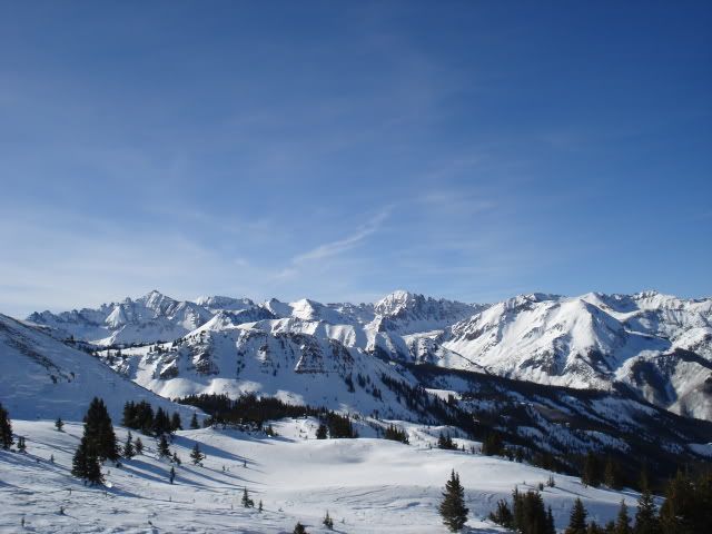
Pretty much right over this, after the first range its almost a straight drop in, from there I belive Pearl is a dog leg around to the left
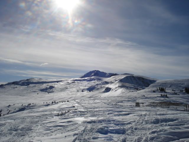
I think the real challenge is the terrain, it get nasty up there.
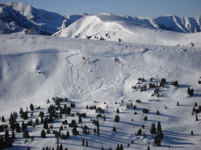
I didnt see this happen, but it was the same day
 There were some XP's blasting around on this stuff when I left, they didnt seem to care
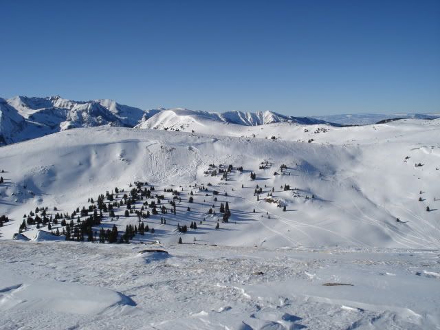
I would bet if you call the old man in the trading post he could tell ya. If anyone would know its him!
I am out of time
RP
I've been up on Taylor a ton of times and I know where Pearl Pass is I just dont know how to get there from Taylor Park. Sure Avalanche scares the krap out of me but I also know there is plenty of great riding over that way without much avalanche danger. I've heard of a way to ge there from Cement Creek I just do not remember what way that was.
Last edited:
Actually I have seen tracks heading up or even over the highest point in your second picture. I would say that the North or Aspen side would not be the side to ride but the South Crested Butte side has more meadows to ride in with some great scenry in the backgroud. And Bruce and Roy in the Trading Post did tell me once but it was a while ago and I thought you guys might have something for me.
Last edited:
Thats his name bruce.
I wassnt trying to preach on slides, just thought som pictures would liven it up
I wassnt trying to preach on slides, just thought som pictures would liven it up
They are great pics, this is my favorite area to ride. There is never anyone there. We go to Aspen for lunch and tear up their meadows.
Access from the CB side was closed to winter motorized traffic with the gang of nine pact. (middle brush creek)
If you have the balls and a rocket you can ride into it from the taylor park side There is alot of PP around the star mine area which would make for the safest access
You could go over Taylor pass and then west to the east side of the maroon bells (if not trespassing). from there you are at the mercy of the avy gods to thread the needle between carbonate peak and pearl mountain not worth it IMO
G
GBCB
Active member
Let us Know
If you pull this off, let us know! I've hunted up in there and you might be able to wiggle thru on back side of Timbered Hill to the saddle of Timbered and Carbonate Peak. After that a little side hilling to the pass between Carbonate and Pearl. After that I couldn't tell ya. I do know very few, if any, jeeps are making thru on the backside the last couple of years which leads me to believe its pretty scary off the back. I know West Brush is open to road only riding (ha, ha). East is completely closed and Gunni Apex is probably right that middle is closed (can't remember). I do know that the skiers give me a real stink-eye when I ride back to West Brush/Deer Creek. Most skiers are heading into East Brush and the Friends hut once you pass West Brush. While FS might not catch you, skiers coming out might get pissed enough to rat you out or break the mirrors off your truck at the trailhead so consider parking at Buckhorn Ranch and riding from there. GOOD LUCK
If you pull this off, let us know! I've hunted up in there and you might be able to wiggle thru on back side of Timbered Hill to the saddle of Timbered and Carbonate Peak. After that a little side hilling to the pass between Carbonate and Pearl. After that I couldn't tell ya. I do know very few, if any, jeeps are making thru on the backside the last couple of years which leads me to believe its pretty scary off the back. I know West Brush is open to road only riding (ha, ha). East is completely closed and Gunni Apex is probably right that middle is closed (can't remember). I do know that the skiers give me a real stink-eye when I ride back to West Brush/Deer Creek. Most skiers are heading into East Brush and the Friends hut once you pass West Brush. While FS might not catch you, skiers coming out might get pissed enough to rat you out or break the mirrors off your truck at the trailhead so consider parking at Buckhorn Ranch and riding from there. GOOD LUCK
I've actually been up to the saddle between Crystal and Star Peak and was thinking there might be a way there too. I was thinking about waiting untill after the Grand Traverse race and the Cross Country tracks would show me how to get down the Creek. As for going from the Aspen side or from Taylor Pass I dont want to die, all the pictuers of the pass on that side look like death untill you get to the very top and that still does not look that safe. I will ask Bruce or Roy again.
G
GBCB
Active member
That won't work
The pass between Star and Crystal is, in fact, Star Pass. You can get to this point from Cement Creek but it will drop you into East Brush and the Friends Hut. It does look feasible to ride up into the saddle on the Northeast side of Carbonate but then what? I'd also practice my CPR. If a skier sees you in there they'd have a heart attack!
The pass between Star and Crystal is, in fact, Star Pass. You can get to this point from Cement Creek but it will drop you into East Brush and the Friends Hut. It does look feasible to ride up into the saddle on the Northeast side of Carbonate but then what? I'd also practice my CPR. If a skier sees you in there they'd have a heart attack!
That is what I was thinking, If it i not wilderness than why would a snowmobile not be allowed in there?
G
GBCB
Active member
Gang of Nine
About a dozen years ago a group of interested parties (skiers, snowmobilers, FS, and tree huggers) got together and formed a winter recreation travel management plan for the entire CB area. Certain areas got the total axe from sledding. This ban includes Middle and East Brush drainages. Cement Creek and Farris Creek are unrestricted while West Brush and Deer Creek are restricted to road riding only (meant for sled/ski access). The whole plan was before real mtn sleds were born. Kind of a bummer for East Brush 'cause you can get in there from Cement Creek over Hunter Hill and Star Pass. However, the Friends Hut does have great skiing 'cause of the lack of sleds up there. While it snows more up Kebler, the riding acreage in upper Spring Creek/Reno Divide/Italian Creek/Upper Taylor is amazing and underutilized. Try riding up Italian Creek and over Eyre Basin then back into Taylor for a thrill. Heading to Denver for Thangiving but happy to answer any more Q's next week.
About a dozen years ago a group of interested parties (skiers, snowmobilers, FS, and tree huggers) got together and formed a winter recreation travel management plan for the entire CB area. Certain areas got the total axe from sledding. This ban includes Middle and East Brush drainages. Cement Creek and Farris Creek are unrestricted while West Brush and Deer Creek are restricted to road riding only (meant for sled/ski access). The whole plan was before real mtn sleds were born. Kind of a bummer for East Brush 'cause you can get in there from Cement Creek over Hunter Hill and Star Pass. However, the Friends Hut does have great skiing 'cause of the lack of sleds up there. While it snows more up Kebler, the riding acreage in upper Spring Creek/Reno Divide/Italian Creek/Upper Taylor is amazing and underutilized. Try riding up Italian Creek and over Eyre Basin then back into Taylor for a thrill. Heading to Denver for Thangiving but happy to answer any more Q's next week.
How do I get in Eyre Basin from Italian? I've been up in Italian and am looking at Google Earth right now and was wondering what way to take to get in there. Also upper Taylor is not underused, there is always fresh tracks for me that way.
I've beenresearching this a little and found some pics. If you go through Star Pass there is a small ridge to the North that looks like if you dropped in over that it would drop you into what I think is Pearl Basin or something. You would drop in above the Friends Hut. Would this be considered restricted? I would not think this would be considered East Brush Creek because you are above it.
I've been researching this a little and found some pics. If you go through Star Pass there is a small ridge to the North that looks like if you dropped in over that it would drop you into what I think is Pearl Basin or something. You would drop in above the Friends Hut. Would this be considered restricted? I would not think this would be considered East Brush Creek because you are above it.
I think you are looking to go between pearl pass and carbonate hill?
attached is a topo of the area above the friends hut, star pass is seen between crystal and star peaks
The area between carbonate and pearl mnt would be nice to drop into, its not that big of an area. if you go down the creek from carbonate to middle brush creek you will end up in either "ride on road" only or wilderness areas as the wilderness starts at the bottom of the switch back (north/right side of the road) and parallels the road down middle brush.
If you have a rocket and a train car full of balls you can drop into the aspen side of pearl pass it is much bigger than the Gunnison side. Only problem then would be the HUGE avy's possibly coming of Pearl peak and getting back over to the gunny side if not going on to aspen would be interesting

Yeah I think coming from the Aspen side is just about death. I've actually been to Aspen a bunch of times and it is hardly worth it, the trail is so rough after you get past the last meadow you need a break when you get there.
G
GBCB
Active member
Eyre Basin
You can see Eyre Basin on the topo Gunni Apex posted. A better map, in my opinion, is one the one from Lattitude 40. It'll show you where the trail is from the ridge of Italian Mountain down into upper Taylor River. I think we're all on the same page as the route to Pearl thru East Brush. The closure is drainage wide in East Brush so technically still a poach but I think doing it on frozen snow in the spring after the Grand Traverse as you've proposed is certainly harmless. Sounds like a really great adventure- good luck and keep us posted.
You can see Eyre Basin on the topo Gunni Apex posted. A better map, in my opinion, is one the one from Lattitude 40. It'll show you where the trail is from the ridge of Italian Mountain down into upper Taylor River. I think we're all on the same page as the route to Pearl thru East Brush. The closure is drainage wide in East Brush so technically still a poach but I think doing it on frozen snow in the spring after the Grand Traverse as you've proposed is certainly harmless. Sounds like a really great adventure- good luck and keep us posted.
Thats what I am thinking. I think I know how to get over to Eyre Basin from Italian. Sounds like another fun adventure.