
Make sure you have a good shovel this winter......especially if you live in Washington, Oregon, northern Idaho, Montana, Wyoming, North Dakota, northern Minnesota, British Columbia, the Canadian Prairies, or Labrador!
=========
Saturday, Sep 14, 2024 - 02:55 PM
The National Weather Service's Climate Prediction Center wrote on X this past week that the probability of a La Nina weather pattern now stands at 71% and "is expected to persist through January-March 2025," adding, a "La Nina watch remains in effect."
La Nina odds are currently higher, yet CPC expects the weather phenomenon to be "weak."
"A weaker La Niña implies that it would be less likely to result in conventional winter impacts, though predictable signals could still influence the forecast guidance," the weather agency wrote in an update.
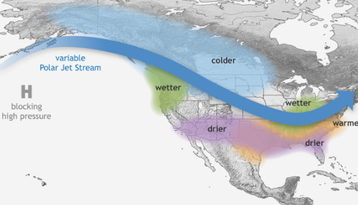
La Nina patterns occur when sea-surface temperatures along the equator in the Pacific Ocean cool. The cooler waters push the jet stream northward, allowing more precipitation across the western US. Due to the movement of the jet stream, areas of the southern US record less precipitation than normal during La Nina patterns.
Ben Noll, a meteorologist with New Zealand's National Institute of Water & Atmospheric Research, provided more color about the La Nina weather pattern on X:
Here are the typical La Nina impacts across the Lower 48:
Meteorologist Noll provided a new update on forecasted snowfall anomalies across the Lower 48.
And this.
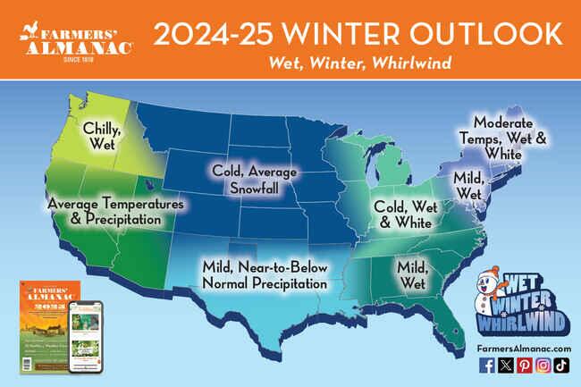
In mid-August, the 208th edition of the Farmers' Almanac published the "Wet Winter Whirlwind." It noted, "There will be a lot of precipitation and storms"—all dependent on location."
Meanwhile, in Europe this weekend.
Ahead of winter in the Lower 48 (2023 data via Angi).
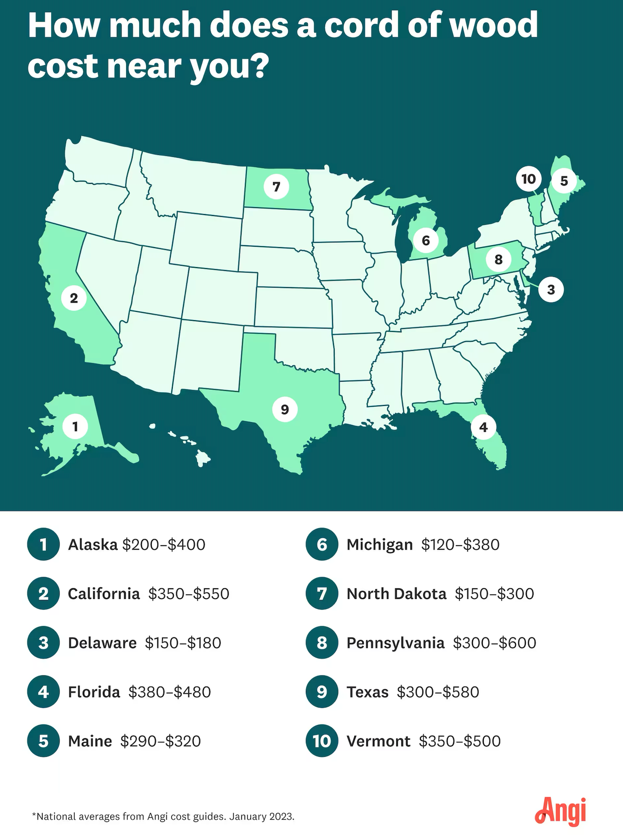
Power bills are only getting more expensive for cash-strapped households battered by Biden-Harris' inflation storm. Consider heating your home with wood or coal to offset electric costs if you can.
 www.zerohedge.com
=========
La Nina "Favored To Emerge In September-November" & "Persist Through January-March 2025"
Saturday, Sep 14, 2024 - 02:55 PM
The National Weather Service's Climate Prediction Center wrote on X this past week that the probability of a La Nina weather pattern now stands at 71% and "is expected to persist through January-March 2025," adding, a "La Nina watch remains in effect."
La Nina odds are currently higher, yet CPC expects the weather phenomenon to be "weak."
"A weaker La Niña implies that it would be less likely to result in conventional winter impacts, though predictable signals could still influence the forecast guidance," the weather agency wrote in an update.
La Nina patterns occur when sea-surface temperatures along the equator in the Pacific Ocean cool. The cooler waters push the jet stream northward, allowing more precipitation across the western US. Due to the movement of the jet stream, areas of the southern US record less precipitation than normal during La Nina patterns.
Ben Noll, a meteorologist with New Zealand's National Institute of Water & Atmospheric Research, provided more color about the La Nina weather pattern on X:
The ocean has taken some significant strides toward La Niña thresholds in recent weeks.
Trade winds have been much stronger than normal, causing upwelling of cooler, sub-surface waters.
This year, the sub-surface is quite a reservoir of cooler than average water, primed to be moved toward the surface as wind stresses come and go.
Traditional indices suggest this year's La Niña will be of a weak to moderate variety.
However, alternative approaches like the Relative Oceanic Niño Index (RONI) offer a different view. This index, which compares the sea surface temperature anomaly in the central equatorial Pacific with the rest of the global tropics, is a better indicator of the ENSO-related change of rainfall and thunderstorms patterns, particularly in a warming world.
RONI suggests that a moderate to borderline strong La Niña is possible. In fact, recent values of RONI have dipped to -0.75˚C, in La Niña territory!
On the balance of recent trends and guidance, and considering the increasing frequency of La Niña in recent decades, I continue to think that La Niña 2024-25 has room to develop into a formidable event...
Here are the typical La Nina impacts across the Lower 48:

Meteorologist Noll provided a new update on forecasted snowfall anomalies across the Lower 48.
And this.
In mid-August, the 208th edition of the Farmers' Almanac published the "Wet Winter Whirlwind." It noted, "There will be a lot of precipitation and storms"—all dependent on location."

Meanwhile, in Europe this weekend.
Ahead of winter in the Lower 48 (2023 data via Angi).

Power bills are only getting more expensive for cash-strapped households battered by Biden-Harris' inflation storm. Consider heating your home with wood or coal to offset electric costs if you can.
La Nina "Favored To Emerge In September-November" & "Persist Through January-March 2025" | ZeroHedge
ZeroHedge - On a long enough timeline, the survival rate for everyone drops to zero
www.zerohedge.com