
F.Y.I. Posted this in the IDAHO riding section, but thought it could use some more visibility. Any help would be great...
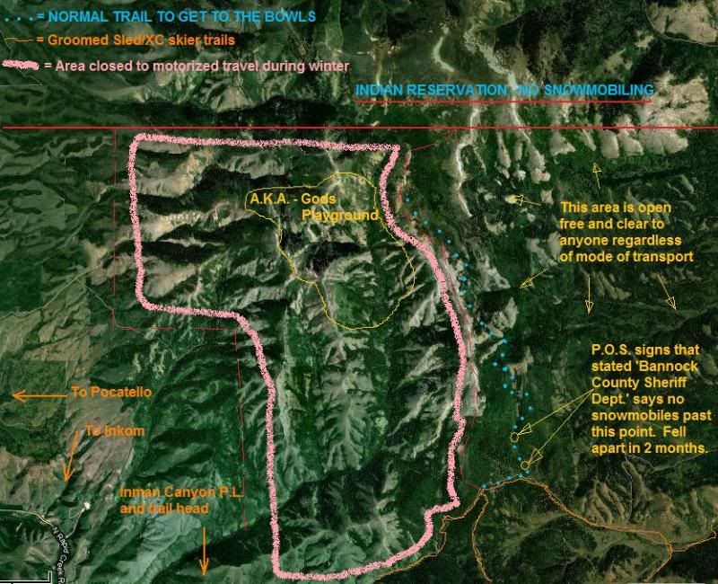
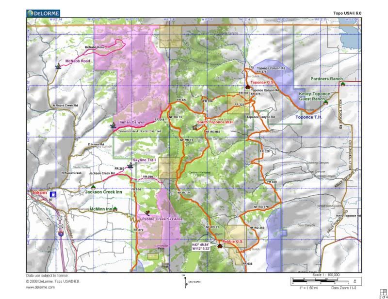
I need some input/info from anyone that knows. I know that parts of the Inman riding area have been closed to motorized travel for a couple years after some 'less fortunate' enthusiasts threw a fit about snowmobiles 'ruining' there areas for skiing/snowboarding. What I don't know is WHO was all involved on either side and WHO is supposedly enforcing these non-motorized areas. I have included a couple pics for reference.
My biggest problem was seeing signs in our main access route that stated that 'Bannock County Sheriff Dept.' was enforcing the 'off-limits' area punishable by law if anyone was caught riding past the 2 points. Problem is (1) It's forest service land with access roads all over and there was NO........NONE.......NADA reference about ANYTHING forest service on the closure signs. (2) WHY were these signs posted on a access trail outside the closure area that also lead to many other areas open to anyone during the winter??? These signs were cheapo P.O.S. too. Looked like laminated printer paper stapled to plywood and nailed to trees. They were trash and couldn't even be read by the end of the winter they were put up. No new ones have been installed since the first ones were put there either.
I never saw anything about a possible closure until the F.S. sent out a memo stating that new maps were available for S.E. Idaho snowmobiling. Can anyone give me some additional details about this? I know actions speak louder than words most the time, but how do we act if we never even know small areas like this are being shut down? Thanks in advance.
racer
I need some input/info from anyone that knows. I know that parts of the Inman riding area have been closed to motorized travel for a couple years after some 'less fortunate' enthusiasts threw a fit about snowmobiles 'ruining' there areas for skiing/snowboarding. What I don't know is WHO was all involved on either side and WHO is supposedly enforcing these non-motorized areas. I have included a couple pics for reference.
My biggest problem was seeing signs in our main access route that stated that 'Bannock County Sheriff Dept.' was enforcing the 'off-limits' area punishable by law if anyone was caught riding past the 2 points. Problem is (1) It's forest service land with access roads all over and there was NO........NONE.......NADA reference about ANYTHING forest service on the closure signs. (2) WHY were these signs posted on a access trail outside the closure area that also lead to many other areas open to anyone during the winter??? These signs were cheapo P.O.S. too. Looked like laminated printer paper stapled to plywood and nailed to trees. They were trash and couldn't even be read by the end of the winter they were put up. No new ones have been installed since the first ones were put there either.
I never saw anything about a possible closure until the F.S. sent out a memo stating that new maps were available for S.E. Idaho snowmobiling.
racer