Install the app
How to install the app on iOS
Follow along with the video below to see how to install our site as a web app on your home screen.
Note: This feature may not be available in some browsers.

You are using an out of date browser. It may not display this or other websites correctly.
You should upgrade or use an alternative browser.
You should upgrade or use an alternative browser.
Freaky Storm ...maybe
- Thread starter donbrown
- Start date
ALREADY have a close eye on the Rubies for that FIRST SNOW!!!...
ALREADY have a close eye on the Rubies for that FIRST SNOW!!!...
Southern California is getting lots of moisture (for SOCAL) from the gulf and now this Hurricane might meet a cold front
Dweeb fromMammoth says it will be a "good" dusting in California !
There is a small narrow tropical/subtropical upper ridge that extends from the Mexican Main Land between the TS and the southern tip of Cabo, west to about 136W. Over the next 24 hours, as the current short wave swings through California, a short wave upper ridge follows and effectively pulls the subtropical upper ridge apart. Once split, a Coll forms (upper low) and becomes the dominant steering mechanism beginning Monday night as it changes Hillery’s current course from East to west to one of a more northerly one. The short wave leaving the Asian east coast tonight will be the one that may pick up the remains of Hillary Friday night drawing it northward over parts of California that weekend. The combination of the two systems and considering the cold air on the trof might bring the first good dusting to the high country, next Saturday and Sunday ... 1 - 2 October 2011
There is a small narrow tropical/subtropical upper ridge that extends from the Mexican Main Land between the TS and the southern tip of Cabo, west to about 136W. Over the next 24 hours, as the current short wave swings through California, a short wave upper ridge follows and effectively pulls the subtropical upper ridge apart. Once split, a Coll forms (upper low) and becomes the dominant steering mechanism beginning Monday night as it changes Hillery’s current course from East to west to one of a more northerly one. The short wave leaving the Asian east coast tonight will be the one that may pick up the remains of Hillary Friday night drawing it northward over parts of California that weekend. The combination of the two systems and considering the cold air on the trof might bring the first good dusting to the high country, next Saturday and Sunday ... 1 - 2 October 2011
"Be still, my foolish heart"
The forecast for Mt Lola:
Wednesday: Rain likely. Snow level 8200 feet. Cloudy and very windy, with a high near 37.
http://forecast.weather.gov/MapClic...764648437&site=rev&unit=0&lg=en&FcstType=text
The forecast for Mt Lola:
Wednesday: Rain likely. Snow level 8200 feet. Cloudy and very windy, with a high near 37.
http://forecast.weather.gov/MapClic...764648437&site=rev&unit=0&lg=en&FcstType=text
mammoth forecast says ...
Significant Trof still headed for California by mid week with snow in the upper elevations eventually coming into the Mammoth lakes town later Wednesday 5 October.
Temps will cool each day into Thursday. Models this morning backed off a bit showing more of a NW slider…..then 18z run came roaring back wet for the high country. Snow level by Wednesday night down to 6 or 7K.
At this time it will all depend upon how the upper jet eventually comes through the Central Sierra Wednesday. At the moment the stormlooks pretty good for significant accumulation.
Being that this event is some 5 days away ...
Storm is set for TUES - WEDS 4-5 OCT for California
Temops to drop real fast Tuesday then back to norms next weekend.
Storm is approaching from the north !
National Weather service says 6500 feet at 6 inches and 8000 feet at a foot by WEDNESDAY afternoon between from Truckee to KERNVILLE.
Probability 1-2 inches rain on the north slopes
Truckee 80%
Mammoth 100%
Whitney - INYO/ TULARE /KERN 80%
Los Angeles 30% 1-2 inches rain with snow above 7000 feet on the hills
5-10 inches above 7000 feet how often does this happen?
http://www.weather.com/weather/aler...ificance=W&areaid=CAZ072&office=KREV&etn=0008
http://www.weather.com/weather/aler...ificance=W&areaid=CAZ072&office=KREV&etn=0008
5-10 inches above 7000 feet how often does this happen?
http://www.weather.com/weather/aler...ificance=W&areaid=CAZ072&office=KREV&etn=0008
For the first week of October ... not much.
by mid January in Truckee ... lot more
Plus on Friday morning suppose to be below 25 F from Big Bear to Truckee
Above freezing temps more than 24 hours after Saturdayat 7000 feet
VERY COLD WIND GUSTS AFTER STORM APPROACHONG 100 MPH at the crest ontop Sierras from Kern to Truckee
SNOW STORM EXPECTED TO LAST 4-8 HOURS 1/2 TO 2 INCHES WATER EQUIVALENT
right now forecasters sayins more snow south of Fresno compared to north of Fresno
Forecast still set as stated.
Some forecasters say 1 inch at 6000 feet and 6-12 above 7000 feet .... This is all a hit and miss prediction on snow levels since the storm is a "band"
A rubber (moisture) band being fueled by warm water and cold Alaska air stretched across the Sierras
Severe winds after snowfall.
Temps above freezing after SAT - SUN
Alpine Meadows Ski Resort at Tahoe got around 6 inches of snow last night. Not too shabby being the first week of October!
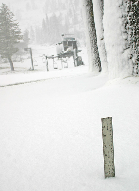

Bear Valley peaks 10000 feet 2 feet
Mammoth at lodge 18 inches
Kern Sherman 9500 ft 12 inches
All the above have been well below freezing since the storm.
Leavitt Meadow 8 inches and sensor says 40F .... Maybe in the sun?
Satellite sensors show more snow south than north ... color coded on NWS map.
Mammoth at lodge 18 inches
Kern Sherman 9500 ft 12 inches
All the above have been well below freezing since the storm.
Leavitt Meadow 8 inches and sensor says 40F .... Maybe in the sun?
Satellite sensors show more snow south than north ... color coded on NWS map.
Last edited:
Similar threads
- Replies
- 11
- Views
- 20K
- Replies
- 2
- Views
- 798
- Replies
- 12
- Views
- 2K
- Replies
- 7
- Views
- 2K
- Replies
- 11
- Views
- 3K
B